Extensive discussions were held with the National Coal Board in regard to past and future subsidence. There were three active collieries operating in the area and the presence of coal seams which were to be worked, significantly influenced the choice of route.
It had been the intention for the motorway to penetrate into Liverpool, as an element of the road network proposed for the central area. Later, however, the City Council abandoned the proposals, due to the extensive property demolition which would have been involved. It was decided, therefore, that the western terminal of the motorway would have to be at an interchange with Queens Drive, a ring road which had been constructed in the 1920's.
The proposed route of the Huyton By-pass had allowed for connection to the A5080, one of the City's main radial routes, and this determined the location of the interchange. The initial problem involved identifying a line through the urban area of Bowring Park, which would have the minimum impact on properties, whilst still allowing access to those not directly affected.
The existing Roby Road had a variable vertical alignment, was fronted by high grade development and was not suitable for upgrading to motorway standard, which would have introduced unacceptable environmental intrusion. It was clear, therefore, that the 'springing point' for the route, as it left the urban area, should be the open land to the south, partly occupied by the Bowring Park Golf Course.
Further to the east, it became evident that subsidence from mining at Cronton Colliery would be a major factor in route location, when it was found in checking an Ordnance bench mark, that settlement of 12 feet had occurred. After discussions with the National Coal Board the proposed alignment was diverted through an area where settlement was complete.
Beyond this point the proposed route passed through mainly Grade 3 farmland. At Burtonwood, however, the former United States Airbase, well known for its involvement in the Berlin Airlift, was still in use as a stores depot. Earlier, the site had been considered for development as a 'Lancashire' International Airport, but this had been ruled out due to mining subsidence. Later advice indicated that this had largely ceased and the decision was taken to align the motorway along the redundant main runway.
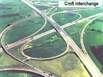
At Croft, where a major interchange would be required at the junction with the M6, various alternative layouts were considered. Significant factors were the very heavy traffic movement between Liverpool and the South, and the drainage of the area. The final design allowed for easy curves with a design speed of 70 mph for the major turning movements, and 40 mph on the slip road loops. In view of the extensive area of land required for the interchange, certain parts within it were to be provided with access, so that they could continue in agricultural use. Other parts were to be used for the disposal of unsuitable excavated material, and landscaped.
East of Risley, the proposed route under consideration traversed Holdcroft Moss, Irlam Moss and Barton Moss, within the area generally known as Chat Moss. Whereas Holdcroft Moss is a virgin raised peat bog, the other parts of the area contain highly productive market garden land, where it was of prime importance to minimise the impact of the motorway.
It was known that peat would be encountered up to a depth of about 20 feet. The only feasible way of constructing the motorway across this area was to remove the peat down to the underlying clay, in order to ensure a stable formation. The critical question, however, was whether the drainage system of the motorway, at such a level, would be able to discharge under gravity. Investigations showed that this could be achieved by laying a long outfall connecting into the Manchester Ship Canal.
The Liverpool-Manchester Railway had been constructed across Chat Moss by Stephenson in the 1850's and, according to local 'folklore', it had been built on 'cotton', implying that bales of the material had been used to stabilise the formation. In actual fact, the story relates to the financing of the project due to the prosperity of the textile industry during that period, with Manchester as the commercial centre and Liverpool as its port. There was some evidence, however, that fascines had been used in the construction.
If settlement takes place in the operation of a railway, it can be dealt with by 'ballasting' under the sleepers in order to adjust the levels. Any deformation of the surface of a motorway can, however, create a potential hazard for high-speed traffic and cannot be remedied in a similar manner.
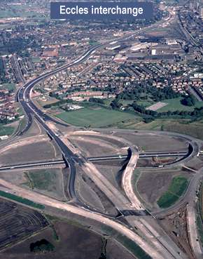
This section of the motorway was to terminate at the Eccles Interchange which had been substantially completed in the contract for the construction of the M602.
It was apparent that if major drainage outfalls, certain earthworks and several bridges, could be completed in advance of the main contract works, the period for the completion of the motorway would be reduced. The first advance contract, which involved the construction of an 84 inch diameter concrete pipe outfall 1267 yards long, from Barton Moss to the Ship Canal, began in February 1970.
At Tarbock, an interchange with the proposed Liverpool Outer Ring Road, M57, was to be constructed, and from there to Risley, the main contract for the construction of 13½ miles of dual three-lane motorway began in September 1971. The works also included two-level interchanges with A57 and A49, in addition to the major interchange with the M6.
The construction of 36 bridges was required, including a viaduct over the West Coast Main Line Railway. The ground adjacent to this bridge had very poor bearing capacity and pulverised fuel ash was used for the approach embankments, the work having been carried out under an advance contract.
At Croft, the Contractor acquired land for a borrow pit adjacent to the site of the motorway, from which 2½ million cubic yards of bunter sandstone were extracted without having to use existing roads for haulage.
The length of motorway between Tarbock and Croft was opened to traffic in November 1973 and a Service Area was later provided at Burtonwood.
Meanwhile, the main contract for the construction of the difficult 6 miles of dual three-lane motorway between Risley and Eccles began in April 1972. Advance works contracts had already been carried out in order to provide access along the line of the motorway. These included drainage outfalls and the excavation of unsuitable material through Holcroft Moss, most of which was a raised peat bog unsuitable for agriculture. It was side-cast to tips on either side of the motorway cutting, which were not allowed to encroach to within 100 feet of the top of the slope. In the very wet areas, where the peat had a moisture content of 1400% a stable slope of 1 in 3 could not be achieved and buttresses of imported material had to be constructed.
Twelve bridges were required, including Barton Moss Railway Bridge carrying the main Liverpool-Manchester Railway over the motorway and designed by British Rail. The works also included the completion of the Eccles Interchange and bridges at Risley for a future junction of the proposed Orford/Risley Expressway.
On completion, in August 1974, there was a continuous length of the M62 in use from Tarbock through into Yorkshire.
Work had begun on the 3½ mile dual three-lane carriageway section of the motorway between Queens Drive and Tarbock, in October 1973.
Due to the urban character of the area at the western end, it was necessary to demolish over 150 houses and small shops, together with two public houses a warehouse and other miscellaneous buildings. This was required in order to accommodate, not only the motorway, but also a 'braided' type of interchange alongside, and over a length of 3/4 of a mile, between Queens Drive, and Bowring Park, where a conventional two-level junction was to be provided.
With a complex urban road system, and two railway lines passing through the area, a large number of structures was required. In addition to two viaducts, ten other bridges, seven subways, and two major retaining walls had to be constructed, together with the reconstruction of several existing bridges.
The 594 feet long Bowring Park viaduct which carries the motorway over minor roads has six spans of twin segmental trapezoidal post-tensioned box beams.
Between Bowring Park and Queens Drive the motorway is in cutting, with residential property on the south side supported by long retaining walls. The extended height of the walls provide a noise barrier and, in the case of some properties, noise insulation was also provided.

Queens Drive is a heavily trafficked Inner Ring Road of Liverpool. A 1030 feet long viaduct carries Queens Drive over the terminal junction of the motorway in seven spans. The single segmental trapezoidal post-tensioned box beam is supported on tapering elliptical piers.
The two viaducts were technically demanding to construct. A travelling gantry was used to lift the units of the Queens Drive viaduct each weighing up to 55 tonnes. Calculations carried out on site had to allow for both vertical and horizontal curvature and superelevation. As the viaduct was constructed in the summer of 1976 when temperatures reached 32°C, exceptional difficulties were experienced. In the event they were positioned on the temporary works to a tolerance of less than ¼ of an inch in any direction.
With the considerable amount of pedestrian movement in the Queens Drive area, four of the subways were constructed in the interchange and particular attention was given to landscaping the approaches.
A long length of Queens Drive was widened and a new carriageway involved the construction of a bridge over the Liverpool-Manchester railway line. Bowring Park Road and Broad Green Road were also widened. In addition to this work, over 3 miles of link roads, slip roads and side road diversions were constructed.
It was recognised that such major works carried out in a largely urban area would cause difficulties for local residents. A member of the supervisory staff was, therefore, permanently allocated to deal with any complaints which might arise.
East of the Bowring Park Interchange and through to Tarbock, the design and construction was that of a conventional dual three-lane rural motorway. Provision was, however, made in the earthworks in cuttings and embankments to accommodate future four-lane carriageways.
The completion of the works in November 1976 marked the end of the construction of the M62 across Lancashire, which had begun 10 years earlier.
Recent schemes
In May 2001, a contract valued at £19.42m was let to Costain to widening carriageways to dual four-lanes between Junction 8 just to the west of Burtonwood Motorway Services Area, and the existing Junction 9 at Winwick. A new grade-separated interchange (Junction 8) was also constructed together with a new link road to the Gemini Retail Park, referred to as the Gemini Link Road. The works involved earthworks, drainage, structures, communications, signing, lighting and pavement construction. The traffic management was designed to maintain three lanes running in each direction during the currency of the works. The contract included the design of piled foundations, sign/signal and MS3 gantries and reinforced earthworks. The project was set up as a full partnership with Highways Agency, English Partnerships, WS Atkins and Costain. The works also included strengthening and widening of several structures including two culverts and Dallam House Bridge which takes the motorway over Sankey Brook. The scheme was opened in November 2002.