M62 Eccles to County Boundary

During the 1930's the need for a fast road route across the Pennines had been the subject of much discussion between the highway authorities in Lancashire and Yorkshire. It was eventually agreed that it would be an extension of the East Lancashire Road, but little positive action was taken before the War, except for the reservation of land for the future construction of an all-purpose road, then known as the Yorkshire Branch Road.

Although the route was included in the 1949 Road Plan for Lancashire, it was not until 1961 that the Ministry of Transport invited the County Councils of Lancashire and the West Riding to survey and recommend a route for the motorway. Reconnaissance on foot was followed by an aerial survey of the whole area and extensive traffic surveys were carried out on both sides of the Pennines. Meteorological data was also examined to identify the alignment which would be least affected by fog, snow and high winds.

The section within Lancashire, presented the design engineers with two principal and contrasting problems. Firstly, there was the task of finding a route through urban areas in the west and north of the Manchester conurbation with its residential property and old industrial workings, and a network of roads, railways, canals and rivers to be crossed. The second problem was the long and steep climb up to the County boundary, where the obstacles were not existing roads but rather the lack of them. In the event, the route which was selected reached an altitude of 1220 feet and, when completed, it became the highest motorway in Britain.

A study of existing records showed that the geology of the route was divided into two sections. The lowland section from Eccles to Milnrow lies on the fringe of the Lancashire plain. Almost the whole of this area is covered by a blanket of glacial deposits and several peat mosses. West of the River Irwell, coal measures had been extensively worked and further subsidence seemed unlikely, but to the east of the river the coalfield was still being exploited. Significant subsidence could therefore be expected, both during construction of the motorway and after it was opened to traffic. In the foothills east of Milnrow there were mudstones, shales, coal seams and sandstone which was fissured, weathered and steeply bedded. Millstone grit formed the Pennine massif and, except for rocky outcrops, the whole of the moorland was covered by a layer of peat up to six feet thick.

Traffic forecasts indicated that dual three-lane carriageways would be necessary. The widths of the strips of land which had been reserved since the 1930's in urban areas such as Prestwich were, therefore, quite inadequate and unfortunately more than one hundred houses had to be demolished and the residents rehoused.

Prior to the formation of the Road Construction Unit, all the contracts for the construction of the motorway were awarded by the County Council. These included several advance works contracts, the first of which began in March 1966.

The principal aim was the building of bridges at key locations in order to provide access for construction traffic along the line of motorway, thereby avoiding the use of existing roads, particularly in the urban areas.

The East Lancashire Road A580 was lowered up to a maximum depth of 50 feet and involved the driving of a 54 inch diameter segmented tunnel outfall 310 yards in length to provide drainage. This work was necessary in order to allow for the construction of Wardley Hall Bridge carrying the motorway over the A580 at the optimum vertical profile. A major structure of eight 120 feet long spans, it was designed to cope with the possibility of future settlement arising from the existence of old mine workings in close proximity to the site.

The bridge over the River Irwell has a single skew span of 200 feet. Ground conditions revealed the existence of an active geological fault - The Pendleton Fault - and underlying shallow coal measures. Although it was founded on rock and it was not anticipated that there would be any major problems, old tunnels were encountered. These had been dug by Brindley to dewater early collieries which had functioned at the turn of the 18th century. Steel box girders supporting a reinforced concrete slab provided a stiff lightweight deck capable of speedy and safe erection and be able to withstand the predicted ground movements.

The most significant bridge constructed in advance of the main works was, however, the spectacular six-span 840 feet long Rakewood Viaduct crossing the Longden End Brook 140 feet above the valley floor. Its early completion was essential to enable the haulage of excavated rock for use in embankments further to the west. Due to the height of the bridge, and the very exposed site subject to severe weather conditions, it was desirable that the superstructure should be capable of erection without temporary falsework and with a minimum of site work. The continuous steel plate girders were launched from one end, braced in pairs.


In May 1968 work began on a series of main contracts. They were all awarded by the Road Construction Unit, with the exception of that for the section between Worsley Court House and the A580. As a 1 mile extension of the Stretford-Eccles By-pass, the scheme was undertaken by the County Council and financed with a 100% grant from the Ministry as a potential trunk road motorway.

The excavation in cuttings, and the construction of embankments, along the whole of the 9 miles of the motorway between Eccles and the County Boundary was a massive operation requiring the movement along the line of the motorway of almost 16½ million cubic yards of material, including 10 million cubic yards of rock.

The strata dipped steeply into the north face of the rock cuttings near the summit, which in places were 120 feet deep. This resulted in sizeable landslips, which necessitated the removal of additional material and the provision of terracing to stabilize the slope. At these locations a wide concrete-lined ditch was provided behind the hard shoulder of the motorway to serve, not only as a drainage channel, but also as a 'rock catcher' to prevent any loose rock from rolling on to the hard shoulder and carriageway.

Apart from the many crossings of existing roads and private accesses, a considerable number of interchanges with major roads had to be constructed. Connections to other elements of the motorway system were provided at Worsley Braided Interchange (M61); at Simister, with the Middleton Link (M66); and at Thornham, with the Rochdale-Oldham Motorway A627 (M). Elsewhere, the A572 and the A575 were connected to the M62 at Worsley Court House; the A666 at Clifton; the A56 at Whitefield; the A6046 at Heywood; and the A640 at Milnrow. Due to the different circumstances at each location, a wide variety in their design characteristics had to be adopted.

Of the 67 structures, there were 7 viaducts and 49 over- and under-bridges. Two bridges, designed by British Rail, carried railways over the motorway the largest being at Besses o' the' Barn. This bridge forms the upper level of a three-level crossing comprising a railway, an all-purpose road and the motorway. The Manchester-Bury two-track railway line is carried at a considerable skew on a three-span prestressed concrete structure and is articulated to cater for anticipated severe subsidence due to coal mining.

The motorway was opened in stages and at a later date a Service Area was provided at Birch, near Middleton. Concurrently, further sections of the motorway were completed within the West Riding of Yorkshire and the historic significance of linking the two Counties by this engineering feat of our age was recognised in October 1971, when the twenty-seven miles between Eccles and Outlane near Huddersfield was formally inaugurated by Her Majesty the Queen.

The Trunk Roads Act of 1936 had transferred to the Minister the responsibility for the major national routes. With a few exceptions, none of the roads within the County Boroughs was given trunk road status.

The original concept of a ring road around the Manchester conurbation was, therefore, considered, by the Ministry, to be the responsibility of the local authorities. Later, however, it was accepted that the proposed Outer Ring Road would have trunk road status, with the Stretford-Eccles By-pass; the section of the M62 between Eccles and the Simister Interchange; and the Middleton Link; as its first elements.


Archive Information

M62 Eccles to County Boundary


The full archive for this scheme is stored at the Lancashire CC Record Office.  Click to see details of this record office, then delete the popup page to return.  There is not yet an Accession Number for this data. 

ITEM DESCRIPTION DATE AUTHOR/ORIGINATOR
1 'Engineer Appreciation'
( pages)

1962

F R Oliver OBE
2 Route Location and Preliminary Design
Personal Memories
(9 pages)

1998

A C Henry
3 Lowering and Dualling the East Lancashire Road A580
(2 pages)

1970

D Barlow
Resident Engineer
4 Lowering and Dualling the East Lancashire Road A580
(3 pages)

1970

L Taggart
R McGregor & Sons Ltd
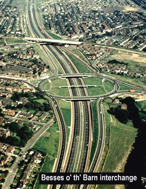
5 Bridge Reconstruction at Besses o' th' Barn.
(2 pages)

January 1968

The Railway Gazette
6 Advance Works
Road and Rail Bridges at Besses o' th' Barn
(2 pages)

1970

J F Davies
Resident Engineer
British Railways
7 Advance Works
Road and Rail Bridges at Besses o' th' Barn
(2 pages)

1970

A B Hewitt
Leonard Fairclough Ltd
8 Contracts M62/1 and 2
Bridgeworks and Preliminary Earthworks at Worsley and Swinton
(7 pages)

2000

A C Henry
9 Contracts M 62/1 and 2
Advance Bridgeworks etc
Liverpool East Lancashire Road A 580 to the Irwell Valley
(3 pages)

1970

R Greatrix MBE
10 Contracts M 62/1 and 2
Advance Bridgeworks etc
Liverpool East Lancashire Road A 580 to the Irwell Valley
(3 pages)

1998

R Greatrix MBE
11 Advance Bridgeworks
Contracts M62/1, 2 and 5

1970

M S Padmore
Costain Ltd
12 Contract M62/2
Worsley to Whitefield Section
(2 pages)

1970

G Cartwright
A Monk & Co Ltd
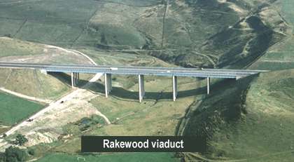
13 Contract M 62/3
Rakewood Viaduct
(3 pages)

1970

A A Smales
Resident Engineer
14 Contract M 62/3
Rakewood Viaduct
(4 pages)

1970

D A Stephenson
Reed & Mallik Ltd
15 Contract M62/4
Advance contract
Milnrow to Rakewood Viaduct

1970

R J Clear
Resident Engineer
16 Contract M62/4
Advance contract
Milnrow to Rakewood Viaduct
(2 pages)

1970

G S Williams
Sir Alfred McAlpine & Son Ltd
17 Contract M62/4
Advance contract
Milnrow to Rakewood Viaduct
(2 pages)

1970

I G Trueman
Leonard Fairclough Ltd
18 Contract M62/5
Advance bridgeworks Heywood to Rochdale
(3 pages)

1970

J H Thomas
Resident Engineer
19 Contract M62/6
A580 to A56
(Basic information file)
(7 pages)

1968

Lancashire Sub-unit
NWRCU
20 Contract M62/6
A580 to A56
( 4 pages)

1970

T E Gartside
Resident Engineer
21 Contract M62/7
Whitefield to Yorkshire Boundary
Basic information file
(9 pages)

1969

Lancashire Sub-unit
NWRCU
22 Contract M62/7
Whitefield to Yorkshire Boundary
(3 pages)

1970

R J Clear
Resident Engineer
23 Contract M62/7
Whitefield to Yorkshire Boundary
(2 pages)

1970

M C Jackson
Sir Lindsay Parkinson & Co Ltd
24 Contract M62/8
Worsley Court House to A580
(3 pages)

1970

C Andrews
Resident Engineer
25 Contract M62/8
Worsley Court House to A580
(5 pages)

1970

J Lindsay Smith
Reed & Mallik Ltd
26 Linking the M62 and M61 Motorways in Lancashire
(11 pages)

April 1971

Roads and Road Construction
27 'Motorway across the Pennines'
The Lancashire-Yorkshire Motorway M62 and Scammonden Dam
Inaugural Visit by HM the Queen
(50 pages)

14 October 1971

Department of the Environment
Lancashire CC
W Riding CC
Huddersfield CBC
28 'Motorways in Lancashire under construction -1969'
(13 pages including photo, maps and diagrams)

1970

Lancashire County Council
Ministry of Transport
29 'England's Mountain Motorway'
(The Lancashire –Yorkshire Motorway M62)
(11 pages including photos, maps and diagrams)

1970

S Maynard Lovell CBE
County Engineer & Surveyor
West Riding of Yorkshire
30 Stability of Slopes on the Lancashire Pennine Section between Rakewood and Moss Moor
Includes paper by E J Arrowsmith covering case histories of four rock slips in the construction of M61 and M62
(Large file with Appendices)

October 1972

Chief Engineer
Lancashire Sub-unit
NWRCU
32 'Commencing the Construction' (2 pages)

1967

H L Yeadon
33 Widening - Junction 14 to 17. Environmental Statement.
Non-Technical Summary, Public Consultation Leaflet. (6 pages)
Draft Side Roads Order.

Sept/Oct 1991

The Department of Transport


Key Dates

M62 Eccles to County Boundary
Statistics and options

First of several contracts started May 1968
M62. Inaugurated by HM the Queen October 1971
Share
Bookmark