The various small-scale plans proposed during the 1930s for a network of motorways showed a line for the North-South route through Westmorland. It was, however, diagrammatic in that no detailed investigations had been carried out at that time.
The perennial difficulties of communications between Scotland and England because of the weather problems of the existing A6 route over Shap Saddle (approximately 1390ft), and keenly felt during the Second World War led to the concept of an alternative route via Tebay and the Lune valley. After the War this was taken up by the Ministry of Transport, and the route was surveyed and set out on the ground.
In 1959 a local resident called a meeting in Kirkby Lonsdale to protest at the route on environmental grounds. The unanimous conclusion of the meeting to condemn the route through the Lune valley was conveyed to the Ministry, who called in Consulting Engineers Scott & Wilson Kirkpatrick & Partners, "to consider all possible and practical alternative routes between the end of the Lancaster By-pass and Penrith, and recommend the one to adopt".
Any route had to deal with an East-West mountain barrier at mid-point that was only relieved by a glaciated valley to the East epitomised by a length near Tebay known as the Lune Gorge. Either use had to be made of this valley or a more direct route had to be found using tunnels and/or high viaducts. In addition to the use of the Lune Gorge, tunnel routes making use of the Long Sleddale valley plus the Lowther or Hawerswater valleys, or along the line of the existing A6 to Shap village were identified: a viaduct route also on the line of the A6 was also identified. Numerous alternatives were found South of the mountain barrier, that could be combined with these resulting in some 30 possibilities to consider. These alternatives were discussed in an Interim Report submitted in mid-August 1960.
A number of special studies were undertaken. Aerial photographs viewed stereoscopically reduced the choice of routes to a few in number. Newly established techniques enabled maps to be drawn of probable depths of rock and the extent of various soil formations. An Origin and Destination survey was carried out so that traffic could be assigned to alternative networks.
Traffic on the A6 was frequently brought to a halt by wintry conditions with bad visibility a particular problem. For the first time on a motorway project, a meteorological study was, therefore, undertaken to judge the effects of wind, low temperature, snow and reduced visibility on traffic using the alternative routes.
The Final Report, in 2 volumes, was submitted by the Consultants in March 1962. In addition to the matters described above, the Report analysed the results of the various surveys and studies, and how they led to three alternatives for final comparison viz;-
* Direct Route
* Killington Route
* Lune Valley Route
The alternatives were described in detail, and the effects of the following factors were assessed:-
* Weather
* Land Use and Landscaping
* Capital and Maintenance Costs
* Traffic Operating Costs
As a first stage, the Killington Route was compared in detail with the Lune Valley Route, and the conclusion was drawn that the Lune Valley Route was to be ruled out and that, if the chosen route was to pass through the Lune Gorge, then it should be the Killington Route.
The Killington Route was then similarly compared with the Direct Route. The choice here was less clear-cut. The Direct Route was shorter, but its capital cost was greater, due to the use of tunnels. A short single 3-lane, unventilated tunnel under Hucks Brow was to carry the climbing North-bound carriageway. Further North at the head of Crookdale, twin ventilated 2-lane tunnels 6,800 ft.long were proposed, one for each carriageway; a third 2-lane tunnel between these two was to be added when justified by traffic growth. This central tunnel could then be bi-directional, used only for climbing traffic, or tidal flow.
Emergency crossing places within and outside the tunnels were proposed. However, the total recurrent costs, comprising traffic operating costs, road maintenance costs, and, in the case of the Direct Route, tunnel operating costs, were shown to be less for the Direct Route even after the construction of the third tunnel.
A cost-benefit analysis showed a return of almost 9% on the additional cost of the Direct Route. Provided the extra capital was available the Direct Route was recommended as the best route from long term, and strategic points of view.
However,
1. it was not possible to rank these returns with those from other road schemes for which the additional funds might be used,
2. the Direct Route was less effective from a weather viewpoint, and
3. the tunnels placed restrictions on the movement of dangerous goods.
For these reasons the Killington Route was selected.
Apart from the terminal interchanges, it was only necessary to provide four junctions with existing roads along the 36 miles of the route.

In carrying out the design, great care was taken to fit the motorway to the landscape, and the designers found that the motorway alignment standards were particularly suited to the terrain, which mean that North-bound traffic would encounter long climbs along certain lengths and desirable constant gradients were achieved in all of these. The reduction of earthworks achieved by stepping carriageways in steep sidelong ground was utilised for 2.5 miles south of Killington, and for 3.5 miles in the Lune Gorge. In the latter case the vertical separation reached 30 ft.
North of Tebay the carriageways are separated over a distance of 4.5 miles, the maximum separation being 800 ft. North of Shap Interchange separation of carriageways occurs over a length of 2.5 miles. It was concluded that sheep farming could continue between the carriageways, and sheep "creeps" were designed along established sheep "corridors" to facilitate this. Protection from drifting snow for the vulnerable lengths North of Tebay was generally achieved by designing embankments with a minimum height of 2 ft and cuttings with side slopes flatter than 1 in 6.5.
It was decided to separate surface water and sub-soil drainage, the former being effected by a specially designed channel section, with an in-line graded approach with slotted steel covers to gulleys. The latter were buried and comprised standard porous pipes together with filter material designed to prevent clogging from the surrounding soil. In one area north of Dillicar Knott larger, deep intercepting sub-soil drains connected to the motorway drainage system were designed to prevent slips in the steep boulder clay slopes.
In order to make use of wet material, and as a result of experience gained from a full scale trial embankment constructed on the line of the motorway, embankments were designed to be laid in 8.5 ft layers separated from one another by drainage layers. In one area of steep sidelong ground deep intercepting sub-soil drains were used above the motorway for additional protection. In pre-determined areas excavation to a vertical face in cuttings was specified to minimise "suitable" material becoming "unsuitable", after periods of rain.
Extensive use was made of computer programs in the calculation of horizontal alignment, intersection and merging geometry, and the setting out of horizontal control lines from setting out beacons. For the first time in this country, actual computer print-out was incorporated into contract drawings.
There are 160 structures on this section of motorway of which 77 are bridges or underpasses. Cost studies led to open abutments being selected generally, so that for standard situations overbridges have three or four spans, but most underbridges have single spans. In one case an overbridge carrying a minor road was designed with 3 spans rather than 4, so as to frame a magnificent early view of the approach to the Lune Gorge for North-bound travellers.
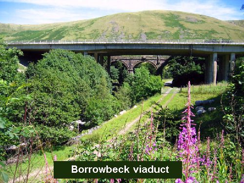
Within a length of 2.5 miles in the Gorge, 8 underbridges were required to carry the motorway, and 3 to carry the diverted A685. The 73 ft high Borrowbeck viaduct is close to and 10 ft higher than the stone arch railway viaduct carrying the West Coast main line to Glasgow. The central span of the curved motorway viaduct was designed to frame the railway viaduct when viewed from the realigned A685, itself on a new curved bridge over Borrow Beck.
The railway line had to be crossed in three places. These were all skew crossings, one having an extreme skew of 70°. Precast reinforced concrete beams square to the tracks were used to minimise temporary works over the railway. For the smaller skews, the free edges followed the skew and a trapezium of reinforced concrete lapped with the precast beams to form a portal construction. For the extreme skew the bridge has beams square to the track throughout, with sections protruding on either side of the motorway construction above.
The location of Service Areas was treated as an environmental as well as an amenity matter. Connecting overbridges were avoided, and sites were selected alternately for North- and South-bound traffic with the two southernmost ones widely separated. However, where the carriageways are separated North of Tebay they are opposite one another. All are designed to provide views away from the motorway, and at Killington the Service Area overlooks the Reservoir and is well screened from the motorway by ground contours.
Construction was to be carried out under five separate contracts for each of the five sections. Contract periods allowing for two full winters of earthwork construction were considered essential. The contract for the section through the Lune Gorge, because of its major structures and large quantities of rock excavation, was given a lead time of 10 months over the other contracts when tenders for it were invited in October 1966. Construction commenced in October 1967.

Jeffrey's Mount provided a 'planning' challenge for the Contractor. The A685 was on the line of the M6, and had to be diverted up-hill to the West as an initial task prior to the construction of the motorway itself. Both A685 and M6 had to be excavated to form ledges in the steep rock with the West Coast line immediately below the latter. Pre-splitting techniques were suggested to tenderers as a suitable technique for avoiding overbreak, and to maintain the stability of up-hill slopes or construction. This technique was used extensively and successfully in this location.
In the event, the condition of the exposed rock proved more difficult than could have been anticipated from visual examination of exposed surfaces, and drill-hole results. The adopted solution was to use rock bolting, previously a little known technique. It was used extensively to good effect.
Where the motorway runs close to and above the railway on steep sidelong ground near Dillicar Knott, a safety fence comprising anti-submarine netting fixed to steel rails concreted into the ground was erected prior to commencing earthworks. It was tested successfully by using a "runaway" D6 crawler tractor.

Also in the Lune Gorge, site access was very difficult, and a preconstructed continuous haul road off the motorway alignment was considered to be imperative. Imported rock from a disused quarry was used to supplement the rock excavations through Jeffrey's Mount and around Dillicar Knott at the entrance to the Gorge. The former provided a continuous source of input to a crusher sited nearby. Material from the haul road was subsequently re-excavated to provide material for drainage layers elsewhere.
Bailey and Callendar Hamilton temporary bridges capable of taking 35 ton loads were used where the haul road crossed the River Lune. The 8,300 ft realignment of the A685 was a first priority, and intricate programming was involved in completing this section.
The motorway was opened in October 1970 with a maximum elevation of 1036 ft compared with that of the A6 it replaced of 1390 ft. It received a Civic Trust Award and the following wording appears on a plaque in a lay-by off the A685 overlooking the Lune Gorge:-
"This award for an outstanding contribution to the appearance of the Westmorland landscape relates to the 36 miles of M6 Motorway between the Lancaster and Penrith by-passes".
From the interchange at the junction with the A65, it was the intention to provide a new high-standard dual-carriageway road running in a northwesterly direction as an improved means of access to South Lakeland. To be known as the Kendal Link, it was to be an 'all-purpose' road and not a 'motorway'. In accordance with Ministry policy, the future maintenance of the boundary fence would, therefore, be the responsibility of the adjoining landowners.
The road was to pass through a deer park and special deer-proof fences would be required. Initially, the landowner concerned raised no objection to the principle of providing the road, but was not prepared to accept responsibility for the fences which were to be erected as accommodation works with the cost met by the Ministry. He, therefore, formally objected at the various stages of the statutory procedures, which led to other objections by interested parties. This resulted in the need for a Public Inquiry and, although the objections were over-ruled in the Minister's decision, it was to be several years before the Link was opened to traffic.
In the summer of 1967, I was a structural design draughtsman working in the comfortable and warm offices of John Laing & Sons in Mill Hill, North London. I was a little disturbed and unsure at that time regarding my future job prospects, because for nearly ten years, I had been advancing my work experience in order to become a qualified structural engineer. But the senior personnel officer (staff were not Human Resources in those days!) told me that I ought to become a civil engineer. In his opinion, I needed a spell in heavy construction; should I see any of their new contracts, which took my fancy, I was to let him know. This is an example of the Laing ethos of the period: I had not been one of the forty graduates recruited annually but, having identified what they thought were my true abilities, they still sought ways by which they could be developed, even where this would take me away from the job for which I had been employed. This attitude developed very strong staff loyalty and today, like many others, I am still proud to call myself a ‘Laing man’!
In the halcyon days of the 1960s, Laing's took great pride in tackling the jobs other contractors did not want. In the early autumn of 1967, it seemed likely that they would win the most difficult English part of the M6 as it approached Scotland through the Lune gorge - a length which the railway builders over a hundred years before had found so daunting. I was apparently the first - and only - volunteer, eventually getting a letter from Personnel asking me to report to the Project Manager he said, "somewhere in the wilds North of Tebay". I was seconded to a separate company, John Laing Construction, whose advanced party had, I found out when I got up there, taken possession of a small disused school just to the North of the village (now a restaurant).
There was an urgent need to overcome the bad weather problems of the main westerly route to Scotland, the A6 over Shap, remembering the fact (not often realised) that Edinburgh is WEST of Carlisle! The road was closed for long periods in the winter and was dangerous on many other days due to poor visibility. I remember that, even during the M6 construction period, long lines of heavy lorries parked for days in and around Kendal, waiting for the snow ploughs to get through. I lodged with an ambulance man Brian Ferguson, who was frequently called out to incidents where a lorry had plunged off the road, often down precipitous fells.
The 36 miles of road, due to be opened as one stretch in the autumn of 1970, progressed south from the completed Penrith By-pass in two contracts, Hackthorpe to Thrimby won by Tarmac Construction and Christiani Neilsen from Thrimby, over Shap, to Tebay. From Lancaster By-pass, W C French (defunct in 1973) came north in two contracts (Carnforth to Farleton and Farleton to Killington). The middle contract, Killington to Tebay (13 miles) had a ten-month lead time over the others owing to the major structures and large amount of rock excavation required; tenders were called in October 1966 and Laing, who were awarded the contract, began construction in October 1967.
There is a wide variation in the weather conditions along this stretch. The Tebay to Penrith section, rising to 320 metres above sea level, is about 50 F colder than the southerly section and is subject to heavy snowfall and hill fog. When Laing asked the Meteorological Office for forecasts throughout our construction, they gave us two - one for the gorge itself and one for the Killington area, which were often markedly different. The Consultant Engineers, Scott Wilson Kirkpatrick and Partners (SWKP) had attempted to minimise interference from snow by infilling the side slopes above Tebay with unsuitable material, making them as gentle as possible. This had two advantages:
• the embankment acted like an aerofoil section, encouraging snow to blow over the motorway and accumulate on the downwind embankment instead of on the carriageways;
• it enabled the land to be given back to the farmers and the fence to be erected at the back of the motorway hard shoulder, thus reducing maintenance.
The fence here was specially designed to allow wind (and snow) to pass freely through; the benefits were lost when safety barriers were introduced later and broke up the smooth flow of air like ailerons on an aircraft.
Service Areas were selected alternately for North (Burton-in-Kendal) and southbound (Killington) traffic, widely separated. There was to be another at Tebay serving northbound traffic only, but a southbound, detached one was added in 1993, where the carriageways are separated. All are designed to provide restful views away from the motorway; at Killington the Service Area overlooks the Reservoir (on which Laing staff started a sailing club which is still in existence), and all are well screened from the motorway by ground contours and planting.
There are 160 structures on the Lune Gorge section of which 77 are road bridges or underpasses; the rest are culverts. Open abutments were selected, so that for standard situations overbridges have three or four spans. Most underbridges have single spans because they serve minor roads or the railway, but notable exceptions will be discussed later.
Extensive use had been made of computers by SWKP in designing the geometry of the road, intersections and structures and for the first time computer printouts formed part of the Contract Documents. This gave us an early problem when Laing's surveyors working north from W C French met Christiani Neilsen coming south - there was apparently a 16 ft. gap in the motorway! Tongue in cheek, both contractors claimed for the additional work, but it was quickly realised that the gap had appeared because the computer had not been programmed to take into account the curvature of the earth - over 36 miles it makes quite a difference! Amazingly, from memory it took SWKP only four days to revise and re-issue the data, remembering that back then, data was fed in by punch cards.
The removal of unsuitable material and the import of suitable had to be kept to a minimum due to the poor access. Much of the excavated material had a very high moisture content and it was specified that cuttings should be excavated to a vertical face to minimise exposure to wet weather (of which there was a lot!). A trial embankment was built, which proved that the embankments could be laid in layers 2.6m thick separated by rock drainage layers. The latter acted as a permeable layer and which assisted in making use of material which would otherwise be too wet. These embankments had to be super loaded for six months before they were stable enough to continue construction of the road on them - another headache for the planners!
For 5.6km around Birk Knott and Jeffrey's Mount, the A685 (Kendal to Tebay) had to be diverted uphill onto a new excavated ledge, with ledges for the two carriageways below, with a maximum vertical separation of 9.1m, all formed by pre-splitting the rock. The West Coast Main Line railway running further below was protected by a temporary safety fence of anti-submarine netting —we proved its worth by testing it with a 'runaway' D6 tractor. Taking so much rock out of one side of Jeffrey's Mount caused the summit to move several inches west! This meant that the setting out control had to be much further away on the adjacent rock formations. The rock proved to be more fractured than had been anticipated and the relatively new technique of rock bolting had to be added to stabilise the cuttings. This has been the cause of continuing maintenance since, as some of the bolts lost their tension. Altogether some 750,000m3 of rock had to be excavated, all used in embankment construction.
The Lancaster/Carlisle M6 was the first in the UK for which the original survey was done from the air, and the control was beacons set into the hill-tops. For over ten years, it had possibly been the most surveyed section of motorway until then, only to find that in 1847, Joseph Locke (then aged 29 and in defiance of the father of the railways, George Stephenson) had bagged the best route for his railway! And it had taken him six months on a horse hired in Carnforth! This is why the road crosses and re-crosses the railway all the way up, to cross Shap by the next lowest summit. This created even more problems for the construction team, liaising with British Railways (BR - not yet privatised) on the construction of the many bridges.
Years after they were built, we had to re-find the bases for the control beacons, short scaffold tubes set into 9inch (230mm) square concrete flush with the ground. They had become covered in heather and scrub and were extremely difficult to spot. We could be almost standing on them without being able to see them. We quickly realised that the farmers saw their land like we would see our garden, and could walk straight to each base, however overgrown they had become. To us it was a remarkable ability on what seemed to us a featureless hillside.
This involvement with remote hill farmers brought a whole new sense of values to us ‘townies’. Their harsh life brought few material rewards, merely a living, but without exception, they were forthright, honest and very down-to-earth. One farmer used his Vauxhall Velox (quite an upmarket car at the time) to drive helter skelter over the fells to pick up injured sheep (and to get us as near as possible to a beacon despite the overpowering smell, always with an enthusiastic sheepdog or two in the back anxious to make friends!). They were a wily lot, with a quiet sense of humour and I learnt to respect them. In the early days one came into the office in his tattered coat belted with twine to tell us "Git thissens home!" It had just started to snow and ignoring his advice was stupid - we only just got back in packed Land Rovers, pushing snow aside with the front bumper! And the things we did to their sheep! "They're not eatin' proper - standin' staring at thee instead!" and "Tha's givin' em heart attacks with all thit banging!", both claims which I was able to refute, along with others of a similar nature.
The surveyors laboriously used theodolites to set out the line of the motorway, main lines of sight having as many as thirty two separate readings to allow for defects in manufacture and reach an average. One of the initial problems was locating the exact centre of each hollow scaffold tube. It was resolved by using bath plugs with the chain pulled out; there must still be a mystified plumbers' merchant in Kendal whom, when he asked why we wanted a dozen bath plugs, was told, "To set out the M6!".
We engineers, assisted the surveyors by setting up the targets and instruments, driving Land Rovers for miles over the fells, down the valley and frequently fording the rivers. The surveyors were nearly all refugees from the diminishing coal industry, led by Dennis Dewsbury from the Nottingham coalfield. I learnt to admire their accuracy and rigorous checking procedures. It took forever to take the many sightings and do the checks, so I spent hours standing shivering up on the summits in all weathers.
Whilst the surveyors (understandably) jealously protected their precious 1 second Wilde theodolites (which always travelled on the seat beside them), we were generously "allowed" to carry the state-of-the-art Distomat, a heavy and cumbersome instrument in a fibreglass box about 30" (76cm) x 24" (60cm), whose power source was a large vehicle battery of only slightly less weight! I certainly got very fit as I trudged up endless steep, rough ground from the Land Rover to set that thing up and bring it back down! Sightings could only be taken when the visibility was good enough, which was usually just before sundown! If the weather was dull, there was a lack of visibility; if the sun shone, there was a surface shimmer which distorted the vision.
The tops of the Westmorland fells in late October are a harsh contrast to warm offices in Mill Hill! At one stage I had on every piece of clothing I had taken up from London with me - including my pyjamas - under the protective clothing supplied by Laing! When the sightings were complete, usually just before sunset, we developed a policy that ‘the last one back pays for tonight's meal’! The rough terrain and rapidly approaching darkness meant that we quickly became experts in righting Land Rovers that had toppled over! Those vehicles were designed to have as many sharp edges in the cab as possible and all of us sported a variety of cuts and bruises.
The isolated community of Tebay, made up of railwaymen and their families, overlooked sidings filled with banking engines used to push the mainline freight and passenger trains over Shap (It was one of their crossover points which was to cause the Grayrigg Pendolino derailment in 2007). The air was always full of smoke and steam, with great piles of coal everywhere. The heavy freight line which branched off to West Auckland via Kirkby Stephen had been closed in 1962, many of the sidings and platforms were disused and only the banking engines remained. One village shop with post office was left in the middle of the main street in a semi-deserted village that had once boasted 700 residents. Not an idyllic spot by any means! The age of steam was coming to an end, the incoming diesel locos and the increasing dominance of road transport meant many residents faced the prospect of serious unemployment.
At the early stages, it was thought that the railway, which interlinked the road for almost its entire length, together with its many sidings and disused stations could be the basis of a supply network for materials, in particular pre-bent reinforcement. But BR's systems proved insurmountable, and deliveries were made to Oxenholme (Kendal) and then onward by a fleet of relatively small BR wagons hauled by three-wheeler Scammell Scarabs. Even stone from Shap came in by lorry.
The dozen or so of the Laing advanced team, largely young men working in appetite-inducing cold, had nowhere to eat lunch. Mr Morgan, the owner of the little shop had a spare room upstairs, and quickly bought a few tables and chairs at auction to provide "chips with everything" lunches - beans, eggs, bacon, mushy peas, sausages - for half a crown [12½p!]. As days went by, the price rose to 3 shillings [15p] and we boycotted!
The Project Manager was persuaded to negotiate, but when he got to the shop the owner had bigger things to discuss: "What," he wanted to know, "Were we going to do for food when the job started?" The logistics were a real headache for John Laing: existing communication up the valley was at best tenuous and small groups of workers, totalling around 1000 altogether, would be scattered over the whole 14 mile length. Pye was experimenting with mobile radio phones (the size & weight of a house brick!) but reception was patchy, erratic and unreliable.
Plans were already in place to build a temporary haul road virtually the full length of the site from which to build the permanent motorway, because the existing road network largely avoided the valley. It had been decided to standardise all the temporary ravine crossings for the haul road as Callendar Hamilton bridges (which, unlike Bailey, allowed for some fatigue) with a span of 110 feet [33.528m].
The outcomes of the lunch discussion was that Laing provided Land Rovers, the shop arranged for the supply of food and containers and staffed the vehicles by recruiting local people. The workforce would pay the drivers for their meals. From these small beginnings a very successful enterprise developed. In fact the whole thing was so successful that we had to curb their enthusiasm - adding morning coffee with pastries and afternoon tea with a choice of cream or jam doughnuts was lovely, but just too disruptive to the works programme!
So the shop owner, his local colleagues, farmers and suppliers had become the employers of a lot of staff. What would they all do when the construction workforce dispersed? What was needed was an alternative outlet! A cooperative (Westmorland Ltd) led by Mr & Mrs Dunning of High Chapel Farm eventually bid for and was successful in winning the service area just north of Tebay, which (now with its partner serving southbound traffic, opened in 1997) is still the only private service station on the UK motorway network and continues to regularly win awards for innovation, locally sourced produce and its high standards from everyone from Egon Ronay to Which magazine - and still uses local suppliers and labour.
The A685 was not strong enough for constant heavy vehicles even when (as we did) lengths were reinforced with a sturdy overlay. Later, one old stone bridge collapsed during a critical earth moving operation. The County Council said it would take a year to replace it, SWKP offered to do it within three months. One of Laing's seconded design staff (Bob Branch) set about doing it much quicker.
With my assistance, he designed and we built a composite deck to sit on what remained of the existing abutments, using second hand rolled steel joists already available from the site stores. I well remember shouting out details of the stud positions through the main office window to the welders waiting to weld them on! We intended to use rapid hardening cement delivered to the North Batcher. Unfortunately, we failed to properly brief the Batcher Foreman and when the first load of concrete came down the road, we noticed the drum was lurching badly. I ran up to the driver and told him to ditch his load immediately - better to lose 6 cubic metres of concrete than a drum (around £6000 I remember)! After that we had the concrete delivered dry and added water at the site. With temporary scaffold parapets, the bridge was back in use in less than a week - and gained retrospective Ministry approval! The stone that we had to take out of the stream-bed was used to face the finished bridge and provide parapets. We were amused when the structure later won an award for its appearance.
My first task at Tebay school was to design several small scale water supply and sewage treatment works to protect the Lune, a beautiful salmon river. A treatment system had to be developed which would guarantee drinking quality water from the effluent from relatively small groups of workers right through the gorge. I resorted to an old Victorian manual for Borough Engineers which I found in the library, which showed how they designed sewage treatment systems for small rural villages; from these I got an idea of sizes, shapes and capacities. But how was I going to persuade the River Authority that my replicas would work before the workmen actually arrived? We built a prototype and loaded it with sheep droppings and cow dung. Once it settled down, it performed beautifully, as did all the others that were built along the gorge throughout construction!
Once the small team found out I had come from the design office, I immediately became a temporary works ‘expert’. There were few guidelines then and certainly no codes of practice. Fortunately the Laing group had a very progressive temporary works department at Mill Hill led by Chris Wilshere; it was usual practice for them, like all the other specialisms in Laing Group, to provide practical support and guidance whenever necessary. How I needed that!
One interesting challenge was to build a multi-use shutter for the many culverts, which were 6 ft. (1.86M) square. Our idea was to construct the floor and to wheel along a shutter for both the walls and roof to be cast in one pour. The three-sided shutter could be struck successfully time after time. It was difficult to see why the culverts were so big, because we could jump across the becks, such as this one at Flodder - until it rained hard! Run-off was almost instantaneous and fast! The culverts took the becks diagonally from the point at which the original beck went under the motorway formation to the point at which they came out. So some were very long; one in particular was from memory 1300feet - appropriately called Long culvert! One unanticipated after-effect of these culverts was that the becks then retained a huge amount of energy, which was dissipated in extensive erosion downstream, much to the wrath of the farmers. Sticking 6 inch square concrete test cubes irregularly to the floor and sides did help a bit, but many field boundaries were re-arranged!
Much of this preliminary work was being carried out before any contract had been signed! I well remember the day when the Contract Manager came into the office and announced we had won the work. It was time for celebrations, but also the time for work to start in earnest! I went out to be the Site Engineer on three major structures towards the south end of the project.
The three bridges were clustered adjacent to the southern of two batching plants, providing concrete of all types for the project, near Grayrigg. The other was near Tebay and both were pan-type mixers, together with automatic batching facilities, a major advance at the time in both increased output and quality control of the concrete. With the 6 cubic yard truck mixers, the batching plants had the added benefit that dry batch could be transported over considerable distances and water added and mixed at the point of delivery. These plants were capable of outputs in excess of 100 cy/h, much greater than the usual requirement for structural work.
This was the time when the Milk Marketing Board decided to stop the collecting milk churns from trestles at the farm entrance and the famers were expected to make their accesses (sometimes as much as half a mile long) suitable for bulk collection tankers. As always on major construction, to err on the safe side, a little more concrete than was calculated was ordered whenever needed. Rather than wash it away, we fixed road forms along these long consolidated tracks and put the surplus concrete in them as it became available; the truck drivers adjusted the stop end as they saw fit. This initiative kept many farmers in the milk business; there was no way they could have afforded to pave their accesses for heavy vehicles themselves.
The three structures were:
The first two were relatively straight forward but even at that time I was concerned about the half joints between the beams and piers. How on earth were the bearings going to be serviced and replaced? It was to prove a huge problem during subsequent maintenance.
The precast beams were being brought in from a casting yard on a disused airfield in Retford, Nottinghamshire. The early part of their journey was relatively straightforward but the winding, narrow roads nearer to the site were to prove a severe obstacle. Even with rear steering trailers, we had to demolish, set back and rebuild several dry-stone walls on the tighter bends to enable the beams to be swung round them. This was particularly true of those for Cowperthwaite, which were longer than the standard length.
Grayrigg consisted of four portals at slight angles; there were ten setting out points, pairs at each end and at each change of direction. These were all given as computed eight figure coordinates. The allowable setting out tolerances made the wall lengths vary from those on the drawings. My proposed adjustments of around ½ - 1½ inches [12.70 - 38.10mm] had to be approved by the Resident Engineer to reach a sensible compromise, something which took an inordinate length of time; he was convinced and said my setting out was "just not good enough". With hindsight it would have been better to restrict the computed coordinates to those of the four outside corners. I thought I had the perfect referencing; setting up on either embankment I could see down into the cutting and then reference the sight line on the existing bridge parapet (a vertical pencil line into wet white paint). It worked fine until a crane ran away and dislodged the coping-stones on a bridge which had stood untouched for over one hundred years! All the setting out had to be re-created which, as many of you will know, is far harder when the job is part built!
The bases were very close to the main line and we had to prove to British Rail that their track would not be disturbed. We did this by driving sheet pile walls on either side and then tying them together with tensioned steel rods in the ballast under the rails. Routine checks throughout construction showed that nothing was moving. The walls were as close to the track as BR clearances allowed, which made construction of their bases particularly awkward. So did the unpredictable ground, which froze during the winter and overloaded the outer unrestrained sheet piling when it melted.
The safety of rail traffic was paramount and BR personnel were housed on site to ensure safety was not compromised. Their site supervisor warned us by blowing a trumpet whenever a train was due (and both freight and passenger traffic was quite frequent!), when we had to stop work, clear everybody and everything within 8ft [2.438m] of the track and turn all jibs etc. parallel to the track with no loads airborne.
There were a number of problems:
One warm sunny afternoon, the lookout changed the flag to green but did not remove the detonators! The train driver dropped the dead man's handle. I have never seen, heard or smelt so much energy dissipated so quickly as the Caledonian express screamed to a halt just before it reached the bridge! The damage to crockery and luggage must have been considerable, though we learnt that no passengers were injured. We heard later that the train barely got to Glasgow, it consumed so much fuel getting going again up Shap incline and the wheels needed attention.
I had to prove from my records that it was not our fault, but that of BR staff. That was when I realised why my Employer insisted on all their engineers continuously keeping contemporaneous records in hard backed books, using every line, with no spaces or paragraphs. It was usually a real pain, because if you did forget anything, you could not insert it later, but had to add it on the next available line. But it also meant that the record could not be tampered with and was thus excellent evidence!
The walls were poured full height in lengths of around 30 feet. No concrete pumps then! All the concrete was laboriously lifted in by 1 cubic yard skips, dropping it via a funnel into a narrow elephant chute down to the bottom of the wall to avoid segregation. External vibrators were used for compaction and with strict discipline and supervision, we never had any honeycombing.
By including the cleaning and repair of the plywood shutter faces in the target times for stripping and re-fixing (and by avoiding burns from poker vibrators), we encouraged the joiners to take exceptional care, resulting in over a dozen uses before they had to be re-faced. Speed was so fast that I was spending too much time using my theodolite to plumb them. So I got a 4lb [1.814kg] plumb bob made in the workshop which, suspended on a long length of twine sheltered between the shutters at the stop ends, enabled the joiners to do it themselves. The Resident Engineer (RE) tried to reason that the walls would not then be vertical, but would slope outwards due to the earth's curvature so that the beams would be short; only the theodolite would ensure they were parallel - I had some difficulty persuading him otherwise!
I tried to cooperate and work with the RE as I had learnt was successful previously, but he had other rather grandiose ideas; he believed he was ‘in charge’ despite having no experience of construction and, as a consequence, made several other silly decisions without discussion. I always tried to do primary setting out on a Sunday, when the site was relatively quiet; when I set out Cowperthwaite I informed him so that he could check it and my referencing if he so wished. I became worried when I was notified in writing that the main span was too large. Luckily my chainman, who had previously been the foreman in a carpet factory, had watched him checking. He had apparently paced it out - down one side of the valley, across the bottom and up the other side! Not for the last time, my chainman had been useful in seeing something going on!
Eventually we lost patience! When we were due to concrete one of the huge bases for this bridge, the RE tried to stop us, saying the base was incorrectly positioned. My chainman and I quietly checked, to find he was sighting the wrong reference peg up on the hillside, so when the general foremen asked me, "Are you sure the base is correct?" I said, "I think so". "Not good enough!" he barked back. "Are you certain it is correct?" "Yes" I said. "Right, let's go!". Such is the responsibility of a mere Site Engineer! The RE issued an instruction to stop, and we had to charge standing time for the concrete gang, the batcher, the truck mixers, the general foreman, me and my chainman, the foremen joiner and steelfixer, a crane, skips and banksman when we proved him wrong. The RE was replaced after this latest of several incidents by a much more reasonable person!
This sour relationship was not isolated. There was a general feeling of discontent that things were not going as well as they should, articulated clandestinely by groups of site engineers in the pubs of Kendal. As a secondee and longer term employee of the Laing group, I was thought less vulnerable than most of the others and went as a representative to see the Laing Structures Engineer at Head Office to outline our concerns, but got nowhere. Indeed, I may have inflamed the situation. But Laings had their own way of sorting things out. All the site engineers were invited by the Personnel Department to a free evening at The Woolpack in Kendal High Street, where drinks and a buffet were on offer. No other staff were present. Shortly afterwards, however, three key people left the job. What effect that evening, and the loosened tongues it had encouraged, had had on the decisions, I don't know, but they were arguably the correct three people! Rumours went round that our new contract manager was the son of a vicar! We naively felt that neither that nor his name were particularly good omens, but Selwyn Charles-Jones was an inspiration, and the whole project was re-born under his leadership.
The portal roof of Grayrigg was formed by precast beams that were incorporated into a slab that turned over the walls to form a rigid joint to form the portal frame. Lifting 420 12 inch wide beams into position required a Sunday possession (no trains) and what was (at that time) the largest mobile crane in the UK, the only 100 ton one owned by Sparrow's. Using the geometry of the crane's lifting range, I was able to arrange the stacking of the beams so that only one shift of position was needed. By pre-arranging accommodation for the Sparrow's men, they had the time to set up the crane and its outriggers on the Saturday evening when it arrived, so that lifting could start at the moment the possession started; six o'clock the following Sunday morning. By nine, when the Resident Engineer turned up with his camera, family and the press, we were finished; we had to lift one beam back off to give the press photographer (and the RE!) a picture!
As we were concreting the deck, BR announced that they required fixings in the roof for future electrification. When the drawings arrived, the fixings were shown positioned very accurately (apparently to 1mm!) about the centre lines of the tracks. But the centre lines were not vertical, being tilted according to the varying and considerable cant (super-elevation) of the tracks. I spent ages trying to calculate where the centre lines would be on the bridge soffit and wondering how to mark them out, until it dawned on me that the given dimensions were exact conversions of whole number Imperial distances! I also got hold of a sample bracket which I realised had a very large degree of adjustment built in! We could fix them between the beams very approximately over each track with just a plumb bob and a bit of common sense!
Although I was not concerned in its construction, there is another (accommodation) bridge just south of Grayrigg at Lambrigg Head, which is different to all the rest, it being a concrete trough. Allegedly this was because the farmer insisted that his cattle would be frightened of the traffic passing underneath if ordinary parapets and railings were used. It was therefore of great interest when we later found he was using the bridge as a sheep dip by damming the lower end; the weight, and the possible corrosive effects of the solution were far in excess of the design criteria and serious proceedings were taken!
Late one afternoon I saw the contract manager's Land Rover approaching. He made straight for me and asked why I wasn't happy. Confused I asked why and he said, "I have been instructed to relieve you of all duties pending your imminent return to Mill Hill". I realised that the reason was that my 12 month secondment had run out, expressed a wish to stay and within days I was transferred to John Laing Construction as Senior Engineer - with a large pay rise and much greater responsibilities! Generally my fellow engineers were pleased for me, but a few of their wives believed their husbands had longer service and therefore deserved promotion.
This promotion involved moving up into the gorge proper, where work was well advanced at Borrowbeck. The curved Borrowdale post-tensioned insitu bridge for the re-aligned A685 was nearly complete. Setting the shutters out had taxed the skills of a very experienced and skilful technician Stuart Ellis, since it was curved both horizontally and vertically. The final profile had to conform to the drawings so the shutters were set to allow for their anticipated deflection under the weight of wet concrete being compacted and then post-tensioned; very successfully as it turned out. I was to learn a lot from his experience.
The 82ft [25m] high Borrowbeck viaduct is close to and 10 ft. higher than the stone arch railway viaduct carrying the West Coast main line, with the central span designed to frame the railway viaduct when viewed from the realigned A685. It was of great interest to us that a tall stone viaduct, constructed in 1850 for what were then, relatively light trains travelling slowly, now had huge Deltic diesels pounding over it at up to 90mph, apparently with no ill effects to the structure.
The columns for the viaduct, whose bases were supported by steel piles, were well under way. The piles had been problematic; they were to be driven to hard rock, welding sections on until a set number of blows achieved no further penetration. Some of the piles had been deflected by the steeply sloping rock face and reappeared at the ground surface!
The rumour was that during the compilation of the tender estimate, someone had cast a scale over the general arrangement drawing of the viaduct thinking it was 1/4 inch to the foot [1:48] when it was actually 1/8th inch to the foot [1:96]! So instead of forty feet of support scaffolding, we had to think of a way of casting many 105 ton beams 80 feet up!
These hollow pre-cast, post tensioned box beams were 6 ft x 3 ft [1.829m x 0.914m] which, because of the curvature of the motorway, varied slightly in length around 100-105 feet [30.48-32.00m]; groups of twelve tensioned ½inch [12.7mm] diameter cables curved into the walls and base in many corrugated ducts, which required much ingenuity to retain in position during casting. The hammer-heads were also hollow boxes but of course, for them the post tensioning was in the roof. There were two other bridges with very similar decks, but not so high, at Tebay and Roundthwaite, so a deck solution could be developed for use for all three.
As we started to set out the hammerhead boxes, I went cold! I realised that because of the transition curve, the centre line of the motorway went through the 6ft deep boxes at an angle, not vertically as had been assumed ie the piles and columns had been set out directly from the motorway centre line determined by the surveyors and not from the centre line as it would emerge from the soffit, an error of some 3 inches (75mm). I went to see the Resident Engineer, Tony Chambers, asking him "Are you sitting comfortably?" before confessing "It's in the wrong place!" Again, SWKP responded very positively and quickly, proving that the bridge safety was little compromised by a slightly eccentric live loading. That is why one hard shoulder is wider than the other.
All this time we were struggling with the problem of casting the suspended spans; the beams would have to be cast alongside on the embankment and lifted in. Headroom was restricted because a 33KV cable (as yet not re-routed) swung across the north embankment near the bridge, ruling out a conventional launcher, which slung each beam under itself. So a twin launcher was developed, with two beams slung one on either side. The gantry was launched into space from the north abutment, pulling one beam behind it as kentledge. Being hauled by hawser from its own motors, it went out in a series of surges as the cable expanded to overcome static friction, the nose lurching ever more with each move. I never actually saw it land; I was being sick behind the cabins! When I got back, the temporary bridge Foreman Alan Chadwick put his mighty arm round me and said, "We believed you. We kept pulling!"
Organising the beams so that they could be brought to the launcher in the correct sequence was a challenge. The one advantage was that we had plenty of space on the north embankment for a casting yard. It was decided to move the beams on Slingsby skates, which have very little friction and could be readily turned through ninety degrees whilst supporting some weight, so the beams could be moved lengthways and sideways. The skates ran in upturned Larrsen No2 piles set in low grade concrete on the embankment and continuously welded together. It was a system which worked extremely well, indeed the 100 ton beams could be pushed along by one man. The carefully organised first loading sequence went awry when we realised that if we tried to put all the beams into the first span, the hammerhead would deflect sideways and close the gap. So we had to modify the sequence to fill all three spans gradually.
Whilst all this planning was going on, the hammerheads were being cast in-situ, base and walls in one pour, roof in another; this minimised the sacrificial shuttering inside the boxes. This was different to the beams, whose cavity was formed by large blocks of polystyrene, held down by spacers from the top reinforcement. Post stressing on both beams and hammerheads using CCL jacks and chocks went well, with the required extensions in each strand being slightly exceeded as each strand reached its tension of 12ton. However, as I was climbing the ladder one afternoon, I saw the weep holes in one hammerhead pouring liquid. On closer examination it was grout! Hurrying to the deck, I stopped the grouting team, who had already used twice as much cement as was calculated and had still not filled the duct. I stopped them! In consultation with the RE and his superiors, we cut a small hole in the neutral axis of the box, carefully avoiding the permanent wooden struts for the roof shutter, through which a thin person (me!) with a light was pushed. The tendons were like a giant guitar, having pulled themselves out of the soffit! No wonder the tension extensions we got were so good.
It was decided to demolish the tops of the boxes and rebuild them; the consultant required the grouted cables to be chiselled out with nothing larger than small jack-hammers (HP7s from memory) - in high strength concrete. There followed weeks of deconstruction and delay, causing morale to sink; it was difficult to keep the team motivated and several men left. I tried to persuade the stressing gang that if they burnt off the barrel on each ungrouted tendon, it would merely fall off but had to cut the first one myself to prove it. At the other end of course, the tensile energy was dissipated as 100 feet of cable embedded itself like an arrow in the embankment slope, so safety was paramount.
As ‘reputable contractors’, we were asked to cooperate with the consultant to find a solution. I went down to Mill Hill, only to find from Laing records that similar failures had occurred on the elevated Western Avenue (now M4) and elsewhere. There was clearly already much to learn, so I was very surprised some years later when I found that the Ministry of Transport's Bridge Design Code on stressed concrete was still dated from just after the war. Again, SWKP pulled out all the stops and revised deck drawings which were with us well before we finished demolition. The revised deck was concreted and stressed with no significant problems.
However, four days before Christmas, as we were tidying up for the holiday, a steelfixer was asked to offload bent reinforcement for the new deck from a BR trailer standing on the embankment, so that it could be returned to the Kendal depot. He decided he could get the load nearer where it would be needed, so asked the mobile crane driver to lift the front end and pull the trailer across the carriageway, with him walking alongside to steady it. The jib hit the 33kv overhead line mentioned earlier and he was electrocuted instantly.
I heard the commotion and was about to leave the cabin when our Safety Officer arrived in a rush and literally manhandled me and other senior staff back to our desks, despite my loud and strenuous protestations that we needed to find out what had happened. He made us write down exactly what we knew, saying, "Once you're out there, you'll learn so much more! Now you've recorded what you knew at the time", harsh but vital advice which stood us in extremely good stead during the protracted enquiries and court case. Various people, particularly the prosecutors, must have got very frustrated by my refrain, "I did not know that at the time".
As is so often the case, a number of minor problems combined to form a major accident:
Never believe the mantra about English law, ‘Innocent until proved guilty’; it certainly did not apply to the Health & Safety Executive. However, by far the worst aspect was telling his young wife, with two young children in the next room playing round the Christmas tree. Despite being very largely exonerated, it was a terrible experience which I sincerely hope none of you have to go through and which still, after all this time, occasionally wakes me up at night - was there not something I could have done to avoid it? I had long since learnt to always be careful about safety but I became fanatical after this incident.
SWKP commissioned Terence Cuneo to paint a picture of Borrowbeck. My reward for taking him the odd cup of coffee was to appear in it, along with his trademark mouse! When I retired in 2003 I tried quite hard to find it, to ask if I could have a reproduction, but neither Scott Wilson Head Office nor his Trust knew where it was. By pure coincidence, giving a seminar in Birmingham I found the picture on the wall behind the door of the training room and took a photograph of it. It really does capture the ‘busyness’ of the area, with the launcher working and heavy Euclid dump trucks transporting huge quantities of rock and earth from cuttings to embankments.
The painting clearly shows how the temporary haul road had to descend into the valley to cross the standard temporary bridge span of 110ft [33.52m], and then climb out the other side. The Euclid truck drivers found it useful to charge down one side and use the bridge as a springboard to get as far up the other side as possible before having to manually change down through the gears. Great for them, disastrous for the bridge! So we put enormous speed ramps in, but they just proved another adventure on the roller coaster ride - by hitting them at high speed, the drivers could get virtually their entire load to become airborne, crashing back into the truck further down the slope! So we had to resort (successfully!) to hitting their pay packets if they did not slow down.
The painting was put up for a charitable auction in 2008, but my bid was significantly surpassed by that of Stuart Doughty, the Earthworks Agent around Borrowbeck at the time, who went on to be Managing Director of John Laing Construction and a Director of many other contractors and Consultants, including the Scott Wilson Group. It was not in particularly good condition, but I do hope it can be maintained, if not restored.
I had a brief respite from Borrowbeck when Roger Howe bridge near Tebay was found to have problems. A skewed overbridge carrying the re-aligned A685 into Tebay from the south, it has an in-situ concrete deck, which, after it had been post-tensioned was found to have pulled the corner off the trapezoidal column support under the fixed end. An additional problem was that it had been opened to carry live traffic and it could not be shut because the old road had been closed (the situation in this picture, which came from, of all places, Brisbane Australia!). The deck was lifted very slightly on Freysinnet pancake jacks sufficiently to allow the end of the pier and the bearing to be broken out without disturbing the reinforcement and then cast again. There were obviously some difficulties in ensuring the new concrete was properly compacted but these were successfully overcome and I returned to Borrowbeck.
The temporary works at Borrowbeck and the casting of the beams became the project for my report for the Chartered Professional Review, but just in case I met one of the staid old reviewers, I also sent details of a reinforced frame car park. Temporary works were seen then as somehow not ‘proper’ engineering, an attitude that, I’m pleased to say, has since disappeared. All my manual typing (no cut and paste or deletion/insertion in those pre-computer days) was done for me by a lady who had also left her partner in London. She point blank refused any payment but did agree to have dinner with me provided that:
Needless to say, when we arrived at an Inn in Dent over in Yorkshire, who should be sitting at the next table but one of Laing's agents. It did not take long for rumours to travel the length of the site!
As we finished placing the beams and were thinking about moving the gantry north, I was promoted again, this time to Project Engineer on a different project. I did learn later from my successor that we had ironed out most of the problems and the launching proceeded with no significant difficulties at both Roundthwaite and Tebay.
Article with images: Archive M6 Motorway Lune Gorge 2 Edited version.pdf
| Section | Construction started | Opened to traffic |
| M6 through Westmorland | October 1967 & August 1968 | October 1970 |