As the first two of these Sections of the M6 were constructed within the same timescale, they are considered together. The initial survey, preparation and design was undertaken by the Cumberland County Council as the Minister's Agent Authority. The North Western Road Construction Unit (RCU) was formed on the 1 April 1967. Unlike the County Councils of Cheshire and Lancashire, Cumberland did not participate, and completed the design and undertook the supervision of construction, with their County Surveyor acting as Engineer under the various Contracts.
From the interchange at the northern end of Penrith By-Pass at Catterlen, the selected route for the Penrith to Carlisle Section was along the valley of the River Petteril a tributary of the River Eden. To the west of the West Coast Main Line Railway it was also within the same corridor as the A6 lying to the east. Passing through an agricultural belt of pasture, arable, meadow and woodland, the 12 mile route provided excellent vistas of the Pennine range.
It was proposed that a Service Area would be provided near to the village of Southwaite.
Alternative routes for Carlisle By-Pass were examined both to the east and west of the City, having regard to the alignment of both the A69 to Newcastle, and the A595 linking West Cumberland. However, the existing urban development suggested an eastern route as being preferable, in order to avoid major disruption, although this meant the postponement of improvements to the western approaches to the City.
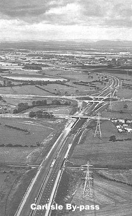
From a two-level interchange connecting with the A6 at the Golden Fleece, the proposed 7 mile route was to pass through a series of cuttings, and under the A69 where a further two-level interchange was to be provided at Rose Hill. Emerging into the Eden valley, with a down-grade to the River flood plain, distant views of the Scottish Lowlands could be seen. After crossing the River and the line of Hadrian's Wall, the motorway was to terminate north of the City at the Greymoorhill Interchange close to the junction of the Carlisle-Edinburgh Trunk Road A7 with the Carlisle-Glasgow Trunk Road A74.
From this point, it was proposed that the existing A74 should be reconstructed over a length of 4½ miles in order to provide a high standard dual carriagway all-purpose road extending as far as the crossing of the River Esk, approximately one mile south of the Scottish Border. The new 604 feet long Esk Bridge was to be the latest replacement for the iron structure originally built by Telford and for a more recently constructed reinforced concrete bridge which, each in turn, had proved to be inadequate for the increased traffic needs. Eight other bridges were required in the reconstruction.
There were similar consultation meetings with members of the public and major landowners to those undertaken for Penrith By-pass. Again, the statutory procedures for the motorway were completed without undue difficulty. The only Public Inquiry to be held, was in respect of the Southwaite Service Area, when fears were expressed at the possibility of intrusion by way of noise and lighting.
A number of advance works contracts were undertaken, the most significant being the Low Hurst Railway Bridge designed by British Rail to carry the West Coast Main Line over the motorway at the northern end of the Penrith to Carlisle Section. East of the City, two other bridges were constructed in advance, to carry the motorway over the Skipton-Carlisle and the Newcastle-Carlisle Railways. Other advance works involved drainage and earthworks, including a surcharged embankment built on the alluvium of the Eden floor plain.
With a population of 75000 in the City, priority was given to the constructions of the Carlisle By-pass section, in order to provide early traffic relief. Work on the main Contract began in December 1968.
Tenders had been invited for alternative forms of construction for the dual three-lane carriageways namely, 'flexible', 'composite' and 'rigid'. The lowest tender, which was accepted, allowed for composite construction but, in the event, the Contractor offered to provide a flexible pavement at no extra cost which resulted in the whole of the M6 through Cumberland having this type of carriageway.
The designed profile had aimed at a balance of cut and fill in carrying out the earthworks, having regard to the disposal of unsuitable material. In a similar manner to the practice adopted in the construction of Penrith By-pass, a 12 inches thick capping layer of bunter sandstone was to be provided below the sub-base.
Apart from those constructed in advance, a further 19 bridges were required, the most significant being the eight span 720 feet long structure carrying the motorway over the River Eden. Preflex Beams composite with a reinforced concrete deck permitted rapid construction.
Where suitable boulder clays and sandstones were encountered at economic depths, the structures were supported on strip footings, otherwise foundations were piled. Wide use was made of Universal beams composite with reinforced concrete decks of up to five spans, carried on piers, bank seats and, in some cases, sloped abutments.
The By-pass was opened to traffic in December 1970.
A separate contract was awarded for the A74 reconstruction and work had started in September 1969 with provision for completion of the Greymoorhill Interchange by the same date as the opening of the By-pass.
Meanwhile, in March 1969, work had begun on the main Contract for the 12 mile Penrith to Carlisle Section which was to be constructed to similar standards.
The boulder clay was found to have a high silt content, thereby making it more susceptible to the adverse effect of wet conditions. The higher pore water pressures made it necessary to make extensive use of bunter sandstone as imported fill, together with the provision of additional drainage. A volcanic intrusion known as the Armathwaite Dyke was encountered, as expected, but caused no particular difficulty as the rock was largely fragmented.
In addition to the advance railway bridge at Low Hurst, 19 other bridges were required. Apart from the use of precast concrete pre-tensioned beams, many of the bridges are to trapezoidal steel box construction. During the design and construction period, considerable development and changes in the design 'rules' took place, most notably leading to modifications to the steel box structures, following the Merrison Report. This resulted in additional diaphragms and stiffeners being inserted in to some of the bridges at a late stage of construction.
The opening of the Penrith to Carlisle Section in July 1971 marked the interim completion of the M6 through the North West Region. It was to be another 37 years before the route finally stretched from the Staffordshire boundary to the Scottish Border, a length of 155 miles.
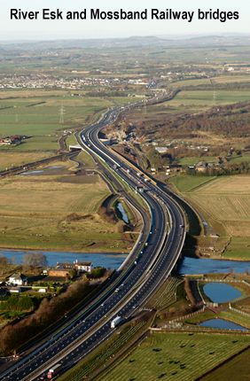
Prompted by problems being experienced with the bridge carrying the A74 over the West Coast Main Line, a £174M DBFO project, involving the upgrading of the connection between Carlisle (junction 44) and Guards Mill (Junction 22 of the A74(M)), was commenced in July 2006. This M6 extension replaced the current A74, generally on the same line, by a new motorway over a 6 mile (10 km) section. In addition, a new all purpose route for local and non-motorway traffic, providing access to nearby villages and properties, was built to the west of the new motorway, using the existing road in places.
The scheme included two major new structures. The Mossband Railway bridge had become life-expired, and a new bridge over the West Coast Main Line railway, carrying both carriageways of the new motorway and the all purpose route, was constructed. The new bridge is a reinforced concrete box structure 160 metres long and 6 metres high over the railway. In order to avoid interference with the rail traffic whilst constructing the bridge, the Contractor devised an innovative moving gantry system, mounted on rails, allowing the concrete walls to be formed in 12 metre sections. Once a section had hardened the system was pulled away from the wall, cleaned and moved along to form the next section. The 136 precast concrete beams for the bridge deck were lifted into place on Saturday nights when Network Rail had the railway closed for their maintenance work, so avoiding further disruption to rail users. Concrete was poured over the beams to complete the bridge structure ready for the road surface. Traffic was diverted onto the new bridge in June 2008. In November 2008, demolition of the old bridge commenced, and was completed in December 2008.
The second major structure was a new bridge crossing the River Esk, alongside the existing A74 bridge. This carried the southbound carriageway. The existing River Esk bridge was upgraded to carry the northbound carriageway and the all-purpose road. The new River Esk Bridge opened to traffic in March 2008.
The Highways Agency's representative was Scott Wilson, the Contractor was Carillion, their designer was Capita Symonds, who employed Grontmij to design the bridges. The Environmental Specialists were Cresswell Associates. The scheme was one of the first projects procured as an Early Contractor Involvement Contract (ECI).
On the 5th December 2008, exactly 50 years after the opening of the Preston By-pass - Britain's first motorway and the first section of M6 - a plaque was unveiled by Transport Minister Lord Andrew Adonis, marking the Official completion of works - the final section of the M6.
|
|
||
|
DX 1958 |
M6 motorway extension; Carlisle to Guards Mill |
2006-2008 |
|
|
Deposited by Mrs Brenda Jackson 16 December 2009 Accession: H9304 |
|
|
|
Printed material |
|
|
DX 1958/1/1 |
Highways Agency brochure, ‘MG Extension; Upgrading the road to motorway standard: Carlisle to Guards Mill. Information brochure given to local residents outlining features of the scheme, the organisations involved, environmental and community issues relating to the scheme and key dates. |
2008 |
|
DX 1958/1/2 |
Copy of press cutting from the Cumberland News (1985) relating to Rockcliffe Press cutting including historical notes and photographs relating to Rockcliffe School. |
|
|
|
Maps and plans |
|
|
DX 1958/2/1 |
Plan of A74 and Todhills Showing individual properties in Todhills affected by the M6 extension scheme |
2006 |
|
DX 1958/2/2 |
M6 motorway extension (Carlisle to Guards Mill) compulsory purchase order key plan |
2006 |
|
DX 1958/2/3 |
M6 Extension, Carlisle to Guards Mill; compulsory purchase order no. 32 (sheet 3) Plans showing plots of land included in the order. |
2006 |
|
DX 1958/2/4 |
M6 Extension, Carlisle to Guards Mill; compulsory purchase order no. 32 (sheet 4) Plans showing plots of land included in the order. |
2006 |
|
DX 1958/2/5 |
M6 Extension, Carlisle to Guards Mill; cross sections at Todhills |
c. 2006 |
|
DX 1958/2/6 |
M6 Extension, Carlisle to Guards Mill; land referencing |
c. 2006 |
|
DX 1958/2/7 |
MG Extension, Carlisle to Guards Mill; plans relating to planting scheme, environmental barriers and fencing |
2006-2007 |
|
|
|
|
|
DX 1884 |
M6 Motorway and Trunk Road A74 reconstruction |
1969-1971 |
|
|
Deposited by Mr Harry Yeadon 26 February 2008 Accession H8480 |
|
|
|
Printed Material |
|
|
DX 1884/1/1 |
Specifications, M6 motorway Penrith Bypass section Booklet detailing extent of works and scope of the contract for the works, including bridge specifications. |
Undated,circa. 1969 |
|
DX 1884/1/2 |
Official opening brochure, M6 motorway and A74 trunk road reconstruction, Carlisle Bypass section This section was opened by the Rt. Hon. W. S. I. Whitelaw, P. C. M. C. D. L. M.P. The brochure includes sections on the route, the works, design and contract details, ground conditions, the carriageways, the bridges, materials and testing, labour and plant, landowners and tenants, statistics, contracts and site organisation, pre—contract works, acknowledgements, staff and conclusions. Includes colour and black and white phtographs drawings and plans. |
Dec. 1970 |
|
DX 1884/1/3 |
Official opening brochure, M6 motorway, Penrith to Carlisle section. This section was opened by R. Graham Page, M.B.E, M.P. Minister for Local Government and Development. The brochure includes sections on the route, the works, design and contract details, ground conditions, the carriageways, the bridges, materials and testing, labour and plant, landowners and tenants, statistics, contracts and site organisation, pre-contract works, acknowledgements, staff and conclusions. Includes colour and black and white photographs drawings and plans. |
July 1971 |
|
DX 1884/1/4 |
Photocopy of paper, ‘The M6 Motorway and the A74 Trunk Road in Cumberland.’ Paper compiled by Mr F. L. Broughton, County Surveyor and Bridgemaster, Cuiuberland County Council |
Undated, circa 1970 |
|
DX 1884/1/5 |
Photocopy of ‘Report on Highway Development in the Immediate Post War Years’ 1943 The report was compiled by Mr G. O. Lockwood, County Surveyor and Bridgemaster of the County of Cuinberland Highways and Bridges Committee. Includes photocopies of correspondence concerning the report, between the Clerk of the County Council and the Secretary of the Committee on Reconstruction Problems, London |
2003 |
|
DX 1884/1/6 |
Photocopies of side order reports for the Carlisle Bypass section of the M6 motorway, 1967 Compiled by Cumberland County Council; the side orders relate to the Carleton to Linstock section. Includes photocopies of objections to the proposed highway |
2003 |
|
DX 1884/1/7 |
File of photocopied press cuttings and articles from professional journals relating to the constuction of the M6 motorway, covering the period 1968—1970 Including: Article from ‘Civil Engineering and Public Works Review, ‘ ‘36 miles of M6 motorway completed.’ November 1970 Article from ‘Roads and Road Construction,’ ‘The Shap Motorway, Lancaster Penrith Sectionof M6 Completed.’ December 1970 Press cutting from ‘The Cumberland News,’ ‘Highway of the 70s’. 11 December 1970 Paper (publication unknown) on ‘Special problems encountered in the design and construction of the M62 in the West Riding and the M6 in Westmorland.’ Cuttings from the ‘Cumberland and Westmorland Herald.’ 1968—1969 Article (publication unknown) ‘M6 in Westmorland.’ undated, circa. 1971 |
1968—2003 |
|
DX 1884/1/8 |
Correspondence relating to the ‘Motorway Memories’ social history project. Includes two letters: From Mrs Mair Bull, widow of Dick Bull, an excavator driver employed by Tarmac. Dick Bull was an itinerant worker in the road construction industry of the 1960s. From Mr L J Cox of Tarmac Construction Ltd. |
1998 |
|
DX 1884/1/9 |
Poem, ‘The Highway’ Poem by Mr Vincent Crean of Tarmac Construction Ltd. |
1998 |
|
DX 1884/1/10 |
File of papers relating to the M6 archive project Includes: Historical notes, list of personnel involved in the construction and details of contractors for individual Cumbrian sections, Ken Gordon, Structures Manager, Curnbria County Council (1997) Obituary of John ‘Dixie’ Dean, Chief Resident Engineer on the M6 and A74 cOntracts from Penrith to the Scottish Border, Ken Gordon, Structures Manager, Cumbria County Council List of available documents and records for the Motorway Archive Project, Cumbria section (Lancaster to Carlisle) (1992—2002) Background notes relating to the construction project, undated. Copy of ‘The M6 Motorway and the A74 Trunk Road in Cumberland’ report on the proposed construction works. Cumbria County Council, undated, circa. 1965 |
1992—2002 |
|
|
Photographic material |
|
|
DX 1884/2/1 |
Black and white photograph of the M6 motorway, showing a section of the recently constructed Penrith bypass The photograph shows the Penrith interchange from the east with Skirsgill site offices and compound. Photograph taken by Turners (Photography) Ltd., Newcastle-upon—Tyne. 28.5cm x 24 cm. |
Undated circa. 1969 |
|
DX 1884/2/2 |
Black and white photograph of the M6 motorway under construction, Penrith to Carlisle section Showing Low Hurst railway bridge, looking north. Photograph taken by Turners (Photography) Ltd., Newcastle-upon-Tyne. 29cm x 24.5cm. |
Undated circa. 1970 |
|
DX 1884/2/3 |
Black and white photograph of the M6 motorway under construction, Penrith to Carlisle section. Showing Plumpton station, looking north. Photograph taken by Turners (Photography) Ltd., Newcastle—upon Tyne. 29cm x 24.5cm. |
Undated circa. 1970 |
|
DX 1884/2/4 |
Black and white photograph of the M6 motorway under construction, Penrith to Carlisle section Showing Catterlen interchange, looking north. Photograph taken by Turners (Photography) Ltd., Newcastle—upon-Tyne. 29cm x 24.5cm. |
Undated circa. 1970 |
|
DX 1884/2/5 |
Black and white photograph of the M6 motorway under construction, Carlisle bypass section Showing the Rosehill interchange looking south along the centre line of the motorway. Photograph taken by Studio Weeks, Carlisle. 30.5cm x 25.5cm. Exhibited at an Elected Representatives meeting (Cumberland County Councilj in October 1969 and was on display in the Directors’ room until December of the same year. |
Undated circa. 1969 |
|
DX 1884/2/6 |
Black and white photograph of the M6 motorway under construction, Carlisle bypass section Showing the Greymoorhill interchange looking south. Photograph taken by Studio Weeks, Carlisle. 30.5cm x 25.5cm. |
Undated circa. 1969 |
|
DX 1884/2/7 |
Black and white photograph of the M6 motorway, Penrith to Carlisle section (location unidentified] immediately following completion Photograph taken by Turners (Photography) Ltd., Newcastle-upon-Tyne. 29cm x 22cm. |
Undated circa. 1970 |
|
DX 1884/2/8 |
Black and white photograph of the M6 motorway, Penrith to Carlisle section (location unidentified] immediately following completion Photograph taken by Turners (Photography) Ltd., Newcastle-upon- Tyne. 29cm x 22cm. |
Undated circa. 1970 |
|
DX 1884/2/9 |
Black and white photograph of the M6 motorway, Penrith to Carlisle section, (location unidentified] immediately following completion Photograph taken by Turners (Photography) Ltd., Newcastle-upon- Tyne. 29cm x 22cm. |
Undated circa. 1970 |
|
DX 1884/2/10 |
Colour photographs of M6 motorway bridges and crossings, Penrith to Carlisle section Including: Two photographs of Lowther Bridge, Penrith, from beneath the morotrway (see slide in DX 1884/2/12) Photograph of Monk’s Lane Bridge, Carlisle, from the motorway embankment (October 1983, see slide in DX 1884/2/12) Photograph of bridge [Linstock] and demolition works, Penrith to Carlisle section, from beneath the motorway (see slide in DX 1884/2/12) Photograph of bridge [unidentified, Lune Gorge?] from beneath the motorway |
1983-1985 |
|
DX 1884/2/11 |
Five packets of photographic negatives showing proposed M6 sites at Penrith |
Undated circa. 1965 |
|
DX 1884/2/12 |
Photographic negatives showing M6 motorway bridges and crossings Including: Four negatives showing Lowther Bridge, Penrith, from beneath the motorway Four negatives showing crossings (location unidentified, Lune Gorge?] |
Undated circa.1985 |
|
DX 1884/2/13 |
Colour slide transparancies, showing M6 motorway bridges and crossings Including: Lowther Bridge, Penrith, from beneath the morotrway (see photograph in DX 1884/2/10) Monk’s Lane Bridge, Carlisle, from the motorway embankment (see photograph in DX 188412110) October 1983 Photograph of bridge [Linstock] and demolition works, Penrith to Carlisle section, from beneath the motorway (see photograph in DX 18 84/2/10) Photograph of bridge [location unidentified, Lune Gorge?] from beside the motorway. June 1985 |
|
| Section | Construction started | Opened to traffic |
| Carlisle By-pass | December 1968 | December 1970 |
| A74 Reconstruction | September 1969 | December 1970 |
| Penrith to Carlisle | March 1969 | July 1971 |
| M6 Extension (Carlisle to Guards Mill) | July 2006 | December 2008 |