M5. The Edithmead (J22) to Exminster (J31)

This contract, which was 5.1 miles long, was awarded to W.C. French and Co. for the sum of £7.51 m. The starting date was February 1971 and it was opened in August 1973. As with the previous two contracts much of the route was on the compressible Somerset Levels, at places 100 ft. deep, and the embankments had to be built in PFA. At Dunball the route passed through the end of the Polden Hills in cutting adjacent to the main Bristol-Exeter railway line which was also in cutting. The design provided for excavating into the hillside to improve the appearance, remove the two cuttings and generate filling and sub-base materials.

Filling material was also obtained for advance construction of embankments on the adjacent length of motorway further south.

As on previous contracts, on the alluvium, a drainage layer was laid directly onto the unstripped turf and topsoil and to prevent damage to the surface crust no heavy plant was permitted to cross the surface before the drainage blanket was in place; the blanket being placed by end tipping across previously laid material.

The construction of the Motorway posed potential problems for the drainage of the Somerset Levels which are the second largest area of fenland in the country. The drainage of the area is achieved by a complex system of ditches and rhynes (or water courses) with the general gradient falling inland to pumping stations where the water is pumped into the rivers Brue, Huntspill and King's Sedgemoor Drain. The rhynes also serve as water supply to animals and as field boundaries. In order to eliminate the need for frequent crossings under the motorway and side roads the drainage was reorganised so that parallel water courses were constructed on each side of the motorway. At Dunball an interchange was constructed to provide a connection with the A39 and the A38. There were 14 bridges constructed on this contract including major bridges over the rivers Brue, Huntspill and King's Sedgemoor Drain.


M5 Bridgwater By-pass (J23 to J24)

This contract, which included the Huntworth Viaduct, was awarded to Cementation Ltd. for a tender sum of £5.26m. The start date was June 1971 and it was opened in December 1973. The length was 4.9 miles and it included the Huntworth interchange. Southeast of Bridgwater the motorway crosses the River Parrot, the Bristol-Exeter Railway, the Taunton to Bridgwater Canal and two minor roads; furthermore as the alluvium at the site would only support a lightweight embankment, a viaduct carrying the motorway for about half a mile over these facilities was an economic proposition. The design was a twin steel box girder construction with a composite reinforced concrete deck. The main spans are 166 ft. and there are seventeen spans with columns founded on large diameter bored piles which extend well into the keuper marl beneath the alluvium.

The design of the structure was undertaken before the publication of the report of the Merrison Committee on Box Girder Bridges. However during the preparation of the design the Engineers in the Sub-Unit worked closely with experts at the Imperial College of Science. Advice which emerged from the University enabled factors to be included in the design which minimized the ultimate problems at the reappraisal stage. In fact only a small amount of extra steel was required mainly in the webs of the box girder compression flanges.

The embankments to the north of the viaduct were constructed in PFA and surcharged to accelerate settlement. In addition to the viaduct six other bridges were constructed as part of the contract.


M5 North Petherton By-Pass (J24 to J25)

This 6.5 mile part of the motorway ran from the Huntworth interchange to the Blackbrook interchange with the A358 road east of Taunton, thus by-passing North Petherton. With continual growth of traffic the congestion in the villages and towns along the A38 in the holiday season, referred to in earlier paragraphs, had worsened. Furthermore the successive opening of sections of the M5 had concentrated the effects by creating worse bottlenecks at the temporary terminals. In order to alleviate these effects in Taunton the section of motorway by-passing the town was completed before the North Petherton section.

The contract was awarded to Arthur Monk Ltd. for a tender sum of £5.72m and commenced in May 1973; it was opened to traffic in November 1975. From the northern end the earthworks were in keuper marls until the River Tone flood plain where firm alluvium were encountered. The alluvium strength was adequate for normal embankment construction and therefore separate bridges were constructed over the realigned River Tone, the Taunton-Bridgwater canal, the main four track railway line and a farm access way. An unseen feature of the works was the requirement of the drainage authority for drains to carry surface water against the direction of the motorway gradient. This was required to reduce the quantity of rapid run off water from the motorway paved area entering the River Parrot catchment at Huntworth; instead water was conveyed further south and discharged into the catchment much further upstream, thus smoothing the surcharge effects. However this necessitated the construction of a deep sewer.

From the outset the contract was bedeviled by difficulties including the receivership of the Earthmoving sub-contractor, consequently the works ran later than required at the Taunton end and the opening date was delayed. In order to remove the traffic from North Petherton, in the summer of 1975, a temporary link to the A38 was constructed by the Somerset County Surveyor's direct labour force. It joined the A38 on a section of dual carriageway at Thurloxton via a strengthened minor road at Moon Lane and required the construction of a temporary road onto the motorway carriageway. This "stop gap" measure worked effectively and offset the worst of the delays.


M5 Taunton By-Pass (J25 to J26)


The Cementation-McGregor consortium were awarded the contract for this 6.9 mile length for a tender sum of £5.02m. The start date was March 1972 and the scheme was opened in April 1974. The scheme required the construction of 14 bridges, interchanges at Blackbrook and Chelston (east of Wellington) and two link roads joining the motorway interchanges to the A38.

This was the first section of the M5 constructed with a concrete pavement. The contract was one of the first to be designed using a new Department specification which encouraged the construction of un-reinforced concrete pavements of reduced thickness on various sub-base depths. In fact the difference in tender price between concrete and a flexible asphalt construction was very small. At the time, and because of some concerns about the specification, the Chief Engineer of the Sub-Unit recommended that the flexible solution be adopted, but this was not accepted.

McGregor's had much experience of operating a Guntert & Zimmerman slip-form concrete paver and had carried out trials for the Department in Nottinghamshire. Techniques had been developed for inserting dowel bars automatically into the contraction joints formed at 6 metre centres. Similarly tie bars were inserted across the two longitudinal joints and preformed joint seals were vibrated into the concrete.

The specification required a protective "thatch" be retained on the earthworks until the formation was prepared and the sub-base was constructed. The profile of the road meant that the most of the soil at formation was keuper marl which at its optimum moisture has high Californian Bearing Ratios (CBR's).

However if allowed to become saturated the bearing value falls to very low figures. The design requirements for the pavement, which it is believed were based on the concept that the formation would be maintained at the optimum moisture content, were for a 10.2 ins deep unreinforced concrete slab on a 3 ins of quality sub-base (type1). In order to haul supplies of sub-base materials and concrete to the paving machine, and avoid formation damage, the Contractor constructed a 9 inch sub-base on the north bound carriageway, materials were then fed across the central reservation to build the south bound carriageway. The added strength of this haul road meant that the concrete pavement thickness was reduced to 9.2 ins.

The potential for future problems, due to sub-grade softening because of water ingress, concerned the designers in the Sub-Unit. Experience elsewhere led them to believe that the formation would not always be at the optimum moisture content. Furthermore, because the specification for type one sub-base permitted a maximum stone size of 1.5 ins ( and allowing for a laying and a formation dimension tolerance) the depth of sub-base could, in places, be barely more than a stone depth; this too was quite outside the comprehension of a number of highly experienced road builders.

As result of these concerns the Ministry's "Concrete Advisory Panel" were consulted. This was a group of three experts who were advising on how to make the concrete roads more competitive and how to resolve difficulties. There is no definitive information available now about their advice but it is apparent that, following their deliberations, no attempt was made to strengthen the sub-base.

Within a very short time after opening this section of motorway it was apparent that problems were developing as mud was pumping out of the joint between the pavement concrete and the hard shoulder on the southbound carriageway. Attempts were made to minimize the difficulty by installing a porous drain in the hard shoulder but this was a failure. After a year or so slabs were deflecting significantly and joints were breaking up. Attempts were made to repair joints but on excavation it was apparent that sub-grade softening had occurred. Consequently a number of slabs were replaced. On excavating the formation to provide extra sub-base and waterproofing it was apparent that the surface failure zone in the sub-grade was generally little more than 4 inches thick. Gradually the southbound carriageway joints and slabs failed and eventually the carriageway was reconstructed On the north bound carriageway the experience was somewhat better. The failures of pavement joints and slabs took longer to occur but in time it was also necessary to reconstruct the pavement before it had achieved a reasonable life.

The situation which led to the expensive failure of the pavement of Taunton By-pass is an example of how responsibility for decisions can become blurred. The specification was laid down by the Department of Environment centrally. The designers in the Sub-Unit and the Chief Engineer, who were unhappy with the inadequate sub-base, were responsible to the Engineer for the Contract, the Director, he took advice from "Experts". Although it is not known what advice was given it is reasonable to assume that, as the sub-base remained unaltered, they recommended that no changes should be made to the construction depth. Had the responsibility been left with the Sub-Unit the construction depth would have been increased. It is somewhat ironic however that had a greater sub-base depth been included in the Contract it is highly probable that due to the added cost to the concrete alternative, the successful tender would have been for a flexible type of pavement.


M5 Chelston to Willand (J26 to J27)

The contract for this 11.1 mile length of Motorway was awarded to Tarmac Civil Engineering (now Carrilion Construction) for a tender sum of £12.49m. The scheme commenced at the Chelston Interchange on the Taunton By-pass and ended at the north end of the Cullompton By-pass where the contract included the removal of the slip roads which connected to the A38 road at Willand. Tenders had been invited for alternative forms of pavement construction and Tarmac's (now Carrilion Construction) successful bid was for an 11inch unreinforced concrete slab laid on 11ins of sub-base.

The earthworks included 2,400,000 cu.yds of excavation in marles and gravels. There were 42 bridges and culverts and one interchange, at Sampford Peverell, which served as connection to Tiverton and subsequently the North Devon Link Road. An area of alluvial plain in the Lyner Valley where the Motorway is on embankment had to be stabilised by placing a layer of rockfill directly onto the un-removed vegetation. Elsewhere, north of the Sampford Peverill Interchange, the route passed through a wooded area. At the design stage bore holes were taken out on either side of the wood as part of the soils investigation: because of the difficulty in gaining access in the wood and because the two bore holes showed similar soils on either side no samples were obtained in the wood. However when the earthmoving machines traversed the wood it was found to be highly unsuitable and very wet, so that much material was excavated and replaced. This incident is reported as an illustration of the importance in soil survey of understanding the significance of types of vegetation and local names. The wood was called, on the Ordinance Sheet, "Aller Wood"; now in Somerset "Aller" is a corruption of "Alder" and alder trees only grow in boggy ground or near to water. Hence had either of these facts been known to the soil investigators their suspicions would have been aroused and maybe the added costs caused by disruption would have been averted.

Tarmac (now Carrilion Construction) used a conventional AGB concreting train operating on rails to pave the full 36 ft. width of each of the carriageways. There were no expansion joints and contraction joints were formed at 20 ft. spacing by vibrating in dowel bars, and sealing strips. On this contract the softened value of the marl sub-grade was assumed to be of a CBR value of 2 . As a result there were no major difficulties with the construction of the carriageway. With the passage of time the riding quality of the carriageway has deteriorated somewhat, particularly due to joint failures, but no major reconstruction has been necessary after 24 years which largely vindicates the concerns expressed by the designers about the inadequacy of the specification on the previous contract.

Nineteen bridges were built on this part of the Motorway the largest being crossings of the A38 on heavy skews at Maidendown and near the end of the Cullompton Bypass. An unusual feature in 1974 was the construction of a 24 inch diameter culvert beneath a large embankment to accommodate a well used badger run. In order to make the atmosphere acceptable to badgers a member of the engineering staff crawled through the pipe towing a dead badger skin.


M5 Killerton Section (J27 to J29)

This 9.7 mile length of motorway comprised two contracts which were awarded to Bovis Construction in May 1973 for a tender sum of £4.83m. The work included the widening of the Cullompton Bypass to three lane motorway standard: a scheme which had been opened to traffic as trunk road bypass in 1968.

To ensure stability of the low embankments across the flood plains of the rivers Culm and Clyst, a protective 25 ins deep crushed rock blanket was placed on the natural ground surface prior to embankment construction. Where embankments were higher than 10 ft longitudinal trenches were excavated in the alluvium, and refilled with rock, to arrest the development of potential slip circles. The earthworks totalled 1,080,000 cu yds. and 8 bridges were built.


M5 Sowton Section (J29 to J30)

Work on this 3.8 mile length of motorway was also commenced by the contractors Bovis in May 1973 for a tender sum of £4.95m and was opened with the length to the north in October 1975. The contract extended as far as the interchange on the A3052 serving Exeter, Lyme Regis and Exmouth at Sandy Gate. It also included a spur road from the interchange to the former Exeter Bypass near Countess Weir. A partial interchange with south facing slip roads was constructed at the A30. As it was only a short distance between the A30 interchange and Sandy Gate there was concern about joining and leaving traffic weaving on the motorway carriageway: in order to accommodate these movements a fourth " collector and distributor" lane was included on both carriageways between the two interchanges. The A30 interchange has recently been amended to provide for entry and exit to and from the motorway in a northerly direction.

The earthworks required 2,641,000 cu yds of excavation, mainly in Permian sandstone, and the removal of some peat below embankments. 10 bridges were constructed in reinforced concrete and British Rail constructed an underline railway bridge as an advanced contract.

M5 Exminster Section (J30 to J31)

This was the most southerly length of the M5. From the termination at the interchange at Pearce's Hill two dual two lane trunk roads continue; the A38 to Plymouth and Torbay and the A30 to Cornwall. The 3.6 mile section from Sandy Gate was let to Cementation Ltd. for a tender price o £12.88m. Work commenced in June 1974 and was completed in time for the opening ceremony by the Prime Minister of the day James Callaghan, now Lord Callaghan, in May 1977. 

The main feature of the contract was the crossing of the River Exe valley where two concrete viaducts were constructed. Each carriageway is supported on separate continuous prestressed concrete boxes which were cast in-situ. The main viaduct over the river comprises 11 spans and is 2263 ft long and the flood relief viaduct is five spans totalling a length of 982 feet. In addition to the viaducts nine other bridges were constucted; one of which, the arch bridge at Pearce's Hill cutting is shown in the accompanying picture.

From Sandy Gate the route passed below the Exeter to Exmouth railway, over the River Exe, the Exeter Canal and the Exeter to Penzance railway and then through a deep cutting at Pearce's Hill. Excavation totalled about 3.174m cu yds of mainly Permian sandstones and breccia examples of which are still visible today in the cutting at Pearce's Hill. Between the two viaducts a high embankment was constructed on the alluvium of the river valley; in order to ensure stability and avoid slips below the embankment rock filled trenches were constructed under the soulders and settlement of the embankment was monitored before carriageway construction was carried out.


Archive Information

The M5 in the South Western Region


List of material held by the Somerset Archive and Record Service


The full archive for this scheme is stored at:

The County Archivist, Somerset Archive and Record Office, Obridge Road, Taunton, Somerset TA2 7PU

Level: Collection Access: Open. Its accession number is: M/582 Catalogue reference: A/BXB

The Office may be contacted by phone on 01823 278805, by fax on 01823 325402, or by Email 


A\BXB/2 M5 Motorway
A\BXB/2/1 Official papers and reports
A\BXB/2/1/1 1969 Copy of the South Western Road Construction Unit Programme issued December 1969.
(1 document)
A\BXB/2/1/2 1977 Report of a working party of the Department of Transport entitled, 'Route Location with Regard to Environmental Issues'.
(1 document)
A\BXB/2/1/3 1979 Pamphlet entitled, 'Trunk Road Proposals - A Comprehensive Framework for Appraisal'.
Prepared by The Standing Advisory Committee on Trunk Road Assessment.
(1 document)
A\BXB/2/1/4 1974-1975 Copy of the Department of the Environment South Western Road Construction Units 7th Annual Report.
(1 document)
A\BXB/2/2 Pamphlets and opening brochures
A\BXB/2/2/1 1973 Pamphlets entitled, 'M5 Motorway in Gloucestershire and Somerset.
Prepared by Consulting Engineers Freeman Fox and Partners to mark the completion of the M5 as far as Edithmead.
Includes an earlier draft version.
(6 documents)
A\BXIB/2/2/2 1971 Opening brochure for the Gloucester-Cheltenham section of the M5 in March 1971.
(1 document)
A\BXB/2/2/3 1969 Opening brochure for the Avonmouth section of the M5 in August 1969.
(1 document)
A\BXB/2/2/4 972 Opening brochures for the Avonmouth Bridge section of the M5 in August 1972.
(2 documents)
A\BXB/2/2/5 1973 Opening brochures for the Dunball to Huntworth section of the M5.
This was opened on the 18th Dec 1973 by the Rt. Hon. John Peyton, Minister for Transport Industries.
(2 documents)
A\BXB/2/2/6 1976 Opening brochure for the Chelston to Willand section of the M5 in October 1976.
(1 document)
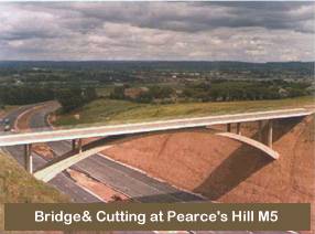
A\BXB/2/2/7 1977. Opening brochure marking the completion of the M5 upon the opening of the Exminster section by the Prime Minister the Rt. Hon. James Callaghan MP on 27th May 1977.
The brochure contains information about the whole of the M5 from Strensham, Worcestershire to Pearces Hill, Devon and includes a separate sheet listing those who were presented to the Prime Minister.
(1 document)
A\BXB/2/2/8 1970 Copies of a pamphlet issued to members of the South Western Association of the Institution of Civil Engineers, who attended a visit to view motorway construction in the South West on the 10th September 1970.
One copy includes the address of welcome from the Director of the Southwestern Road Construction Unit, Mr P G Lyth.
(2 documents)
A\BXB/2/2/9 1972 Pamphlet issued to members of the South Western branch of the Institution of Highway Engineers on the occasion of their visit to view construction works on the Edithmead to Dunball and Dunball to Huntworth sections of the M5 on the 27th September 1972.
(1 document)
A\BXB/2/2/10 1973 Pamphlet issued to members of the South Western branch of the Institution of Highway Engineers on the occasion of their visit to view construction works on the Blackbrook to Chelston section of the M5 on the 25th July 1973.
(1 document)
A\BXB/2/2/11 n.d [c.1974] A pamphlet prepared for the proposed Pearces Hill to Pocombe Link Road A30.
(1 document)
A\BXB/2/2/12 n.d Copies of a paper entitled, M5 Motorway in Devon'.
(4 documents)
A\BXB/2/2/13 n.d [c.1970s] An extract from the magazine New Civil Engineer about the Avonmouth Bridge and a publicity paper by the contractor Fairfield Mabey.
(2 documents)
A\BXB/2/2/14 c.1973 An article about the construction of the M5 from the Avonmouth Bridge to Dunball.
(1 document)
A\BXB/2/2/15 1973 An article from Construction News about the construction of the M5 from the Avonmouth Bridge to Dunball.
(1 document)
A\BXB/2/2/16 c.1973 Extract from a magazine concerning the Edithmead to Dunball section of the M5.
(1 document)
A\BXB/2/2/17 1971 Copy of the Proceedings of the Institution of Civil Engineers entitled, 'Design and construction of embankments on analluvial plain', by N J Dallard.
(1 document)
A\BXB/2/2/18 1972 Copy of the Proceedings of the Institution of Civil Engineers with a discussion on A\BXB/2/2/17.
(1 document)
A\BXB/2/2/19 1972 A report prepared by Devon County Council entitled, 'The Motorway Into Devon: The Challenge'.
(1 document)
A\BXB/2/2/20 c.1990s Chapter 3 from a book by Michael Hawkins, the former County Engineer of Devon, which refers to the M5.
(1 document)
A\BXB/2/2/21 n.d Copies of a map of the M5 motorway from Strensharn to Edithmead, prepared by Freeman Fox and Partners.
(2 documents)
A\BXB/2/2/22 n.d Map of the M5 motorway from Avonmouth to Puriton.
(1 document)
A\BXB/2/2/23 n.d Map of the M5 motorway fromEdithmead to Willand.
(1 document)
A\BXB/2/2/24 n.d Map of the M5 motorway fromEdithmead to the West of Exeter alternative routes.
(1 document)
A\BXB/2/3 Recollections andcorrespondence
ASXB/2/3/1 1999 Letter to F D J Johnson from Brigadier Stanley Baldwin containing his personal recollections.
(1 document)
A\BXB/2/3/2 1994 A paper entitled, 'Bridging the Gaps', by Michael Clerk, a former section engineer in the RCU HQ.
(1 document)
A\BXB/2/3/3 1998 Two letters from Professor R Bridle suggesting sources of material for the Motorway Archive project, together with anecdotal memories.
(2 documents)
A\BXB/2/4 Newspaper cuttings
A\BXB/2/4/1 1967 Copy article on the M5 from the magazine Roads and Road Construction.
(1 document)
A\BXB/2/4/2 1967 Newspaper cutting on the M5 from the Western Daily Press
(1 document)
A\BXB/2/4/3 1967 Copy newspaper cutting on the M5 from the Cheddar Valley Gazette.
(1 document)
A\BXB/2/4/4 1977 Newspaper cutting about the Exminster section of the M5.
(1 document)
A\BXB/2/5 Photographs
A\BXB/2/5/1 1974 83 photographic prints (mostly black and white) of various sections of the M5 Motorway.
(1 bundle)
A\BXB/2/5/2 1971-1972 11 mounted photographs of the M5 motorway under construction and once completed.
(11 documents)
A\BXB/2/5/3 n.d
[c. 1970]
4 photographs of artistic representations of proposed bridges on the M5 Motorway.
(4 documents)
A\BXB/3 Papers of the Trust
A\BXB/3/1 2002 Executive summary report of the Motorway Archive Trust project.
The report was compiled by F D J Johnson, former County Surveyor of Somerset and former President of the County Surveyors Society. It provides a history and context to the construction of a motorway network in South West England.
(1 document)


Dates

M4 Second Severn Crossing Statistics and options

Second Severn Crossing. Construction started April 1992
Second Severn Crossing. Opened to traffic June 1996
Share
Bookmark