In 1951 Sir Owen Williams and Partners were commissioned by the then Ministry of Transport to investigate a route for a motorway from St. Albans to Doncaster, a distance of approximately 140 miles.
The section of the M1 from St. Albans to Crick (Northamptonshire) is described elsewhere and was constructed during 1958 and 1959. The section from Barlborough to Wadworth (Doncaster by-pass) is included on the North East Region pages
In 1960 the Consulting engineers were asked by the Ministry to proceed with scheme preparation and detailed design for the remaining 87 miles from Crick to Doncaster. Tenders for the first contract were invited in 1962 and by December 1967 the whole 87 miles had been constructed.
The project was a direct continuation of the M1 at Crick passing through Northamptonshire, Leicestershire, Derbyshire and into Yorkshire. The route passes close to the western edge of Leicester and passes between Nottingham and Derby, with junctions on the A6 and the A52 Sandiacre By-pass (3 level), before passing to the west of Mansfield and to the east of Sheffield at Thurcroft. The line of the M1 Northwards from Thurcroft was the responsibility of Yorkshire County Council, but a free-flow junction there enabled the route, renamed the M18, to continue in a north-easterly direction to end at the Doncaster By-pass just to the South of Doncaster. (A more detailed description of the M18 can be found here)
Sixteen junctions were constructed on the project, including a free-flow west/south junction with the future M6, the junction at Thurcroft and the terminal junction at the Doncaster By-pass, where provision was made for the M18 to be continued at a later date. There was considerable opposition to the section of road through Charnwood Forest, in Leicestershire, on environmental grounds, but eventually it was decided that the damage to agriculture that would arise from an alternative route was a greater penalty.
The Coal Measures outcrop over much of the route through the Midlands and Yorkshire Coalfields and elsewhere are present at a comparatively shallow depth. Extensive mine workings, past and current, gave rise to a number of problems for which innovative solutions were required. These are summarised below:
As was normal, contractors were allowed to tender for Rigid or Flexible pavements and in none of the tenders was the Rigid option favoured. Pavement design was based on Road Note 29, which had been published since the completion of the sections south of Crick. The four most southerly contracts were constructed with a lean concrete lower base with a nominal 18:1 mix, laid by a selection of machines including graders and paving machines with an without adaptations. On these contracts the carriageway was contained within reinforced concrete haunches, with white concrete tops, which defined line and level. On the remaining contracts, due to the possibility of ground movements due to mining, the pavements were of fully flexible construction and the haunches were dispensed with in favour of conventional, if time consuming, levelling techniques. All carriageways were 36ft wide with 10ft wide hardshoulders.
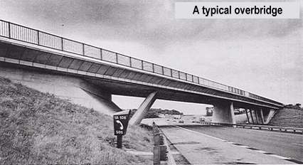
Overbridges from Crick to Stanton-by-Dale had a 3ft thick deck with precast service ducts along each edge which acted as permanent shutters for the deck concrete. The verge supports were generally inclined columns, with a wall support in the central reserve when the skew dictated it. In-situ decks over the supports were linked with 60ft long suspended slabs by reinforced concrete hinges capable of taking shear, thrust and tension. Underbridges were either wall and slab bridges or used precast portal frames on mass concrete abutments.
North of Stanton-by-Dale all bridges were designed to cope with possible ground strains of 3% and change of slope of 1/200, with simply supported spans.
The project was divided into 14 contracts, involving 9 major contractors, running from August 1962 to December 1967 with a total tender price of £60.18m. The Consultant established a Site Control office at Leicester Forest East, from which the Resident Engineering staff on the individual contracts were co-ordinated.
Four Maintenance Depots were constructed by the Ministry and site provided for 5 Service Areas, three of which were developed at the same time as the motorway. As a result of the Motorway earthworks, and also work alongside the road funded by other agencies, many of the existing slag heaps in the coalfields were rounded off and planted, to provide a greatly improved corridor for the motorist to pass through.
|
Contract details |
|||
|
Contractors: |
Whetstone - Crick | George Wimpey & Co. Ltd | Opened: October 1964 to December 1964 |
| Kirby Muxloe - Whetstone | R. M. Douglas Construction Ltd. | Opened: January 1965 | |
| Markfield - Kirby Muxloe | A.Monk & Co. Ltd | ||
| Kegworth - Markfield | Sir Robert McAlpine & Sons Ltd. | ||
| Trent structures | Brims & Co Ltd. | ||
| Sandiacre - Kegworth | George Wimpey & Co. Ltd | ||
| Nuthall - Sandiacre | R. M. Douglas Construction Ltd. | ||
| Pinxton - Nuthall | George Wimpey & Co. Ltd | ||
| Barlborough - Pinxton | John Laing Construction Ltd. | ||
| Thurcroft - Balborough | Tarmac Civil Engineering Ltd (now Carrilion Construction) | ||
| Thurcroft - Wadworth | W. & C. French Ltd. | ||
| Planning Period: | 1960-1966 | ||
| Construction Period: | 1962-1967 | ||
| Opening Date, Final Portion | November 1967 | ||