In October 1956 Harold Watkinson, Minister for Transport and Civil Aviation confirmed the scheme for the first section of the London - Yorkshire Motorway M1 (Luton to Dunchurch).
Construction began in March 1958 and was opened to traffic in November 1959. There was now a new sense of purpose about road building, this was reflected in the Ministers address at the Institution of Civil Engineers in 1957 - "if we can have less verbiage and more mileage of road construction completed we shall at least make a real contribution."
This challenge was readily taken up by the West Riding engineers with the start of the construction of the Doncaster By-pass to be followed by work on the routing of the M1 from Aston to Leeds via Sheffield.
The invitation from the Ministry to the West Riding County Council to undertake preparatory work leading to the publication in 1962 of a Section II scheme for this 35 miles length of the M1 was issued in 1959.
To the north of Wakefield the landscape was one of coal mines and pit-head gear at Kirkhamgate, East Ardsley and Rothwell crossed by innumerable pylons and overhead cables, relieved only by rhubarb fields in the Middleton area on the outskirts of Leeds. According to the locals, the finest rhubarb in the whole of Europe (if not the world) was grown in this locality.
Southwards from Leeds the route ran through the heart of the Yorkshire coalfields, skirting Crigglestone, Wooley Edge, Darton, Dodworth, Birdwell, Tankersley, Chapeltown and Ecclesfield, but much still attractive wooded areas. With mountainous heaps of shale, stark pithead gear, coal and spoil conveyor belt systems and buildings, the whole length was patterned with high and low voltage overhead electricity cables for good measure.
Although a somewhat grim industrial landscape it was where the route squeezed across the Don Valley at Tinsley between Sheffield and Rotherham that routing proved the most challenging. Rivers, canals, railways and heavy industry to be negotiated. "A succession of cooling towers, iron smeltings, steel rolling mills, chemical and dye works, coking plants and the like all competed to pollute the atmosphere."
Fortunately following the implementation of the Clean Air Act in 1963 this is no longer the case.
Once past Tinsley the route swept alongside marshalling yards and industrial gas plants at Catcliffe before finally emerging into open farming county again near Whiston, and thence to join the planned M1/M18 Interchange at Thurcroft. From this point southwards through Nottinghamshire the design of the M1 was in the hands of Consultants - Sir Owen Williams and Partners.
With the agreement of the Department of Transport major traffic surveys were undertaken both for a Trans-Pennine future route (M62) and for M1 (since one had an impact on the other) to establish demand and hence design standards including the optimum position of junctions. A good deal of detailed attention was paid to the heavily-congested Tinsley area in conjunction with the County Borough Councils of Sheffield and Rotherham. The concepts were produced of a three quarter mile long two level viaduct at Tinsley together with an imposing three level motorway to motorway interchange at Lofthouse (the intersection of the M1 and M62).
A draft Section II Scheme to establish the Motorway centre line had been published in December 1961 and the next priority was to try and resolve objections received. In the main these were from Local Authorities and Public Utilities anxious to protect their various installations - sewers, gas mains, electricity cables and the like. As Statutory Authorities they had the power to force a Public Enquiry if their objections were not withdrawn, and a hectic period of consultation ensued. In the areas of concentrated industrial development negotiations were particularly difficult, the firms concerned, many of national and international importance, being understandably anxious about matters of continuous access (both road and rail) and uninterrupted power supplies.
Early priorities were the aerial and soil surveys. Some preliminary soil survey work had been undertaken and boreholes sunk using the resources of the County Laboratory based at Ossett.
Four contracts covered the detailed soil survey for the 36 miles of the route. Tenders for the first (from Aston to Tinsley) were invited in the summer of 1962, this was won by Soil Mechanics Ltd., as was the second (Tinsley to Tankersley). In due course the third (Tankersley to Crigglestone) and fourth (Crigglestone to Leeds) were awarded, to Cementation Ltd. and to Wimpey (Soils Division)
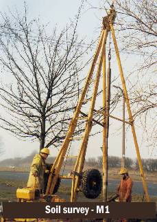
Boreholes were taken at about 100 yard intervals and samples were tested for bearing capacity which determined the thickness of construction to be used, suitability for forming embankments, and for determining the loadings which could safely be used in the design of bridge piers and abutments.
The soil survey also revealed such features as the presence of saleable coal which was to be excavated when the road was built and the existence of old shallow workings and shafts in coal seams and bell pits from iron ore mining. A great number of uncharted ancient shallow workings were revealed in the course of the M1 soil survey and failure to have located them could have had most serious consequences. Accurate fault line identification was also vital to the bridge designers.
M1 Soil testing
The cost of the survey work was £183,000 for the Yorkshire section of the M1, but the savings accruing from the more refined designs made possible from the information obtained resulted in savings which outweighed the costs many times over, as well as ensuring a safe motorway through very difficult ground.
Generally speaking, however, the fieldwork went well. It was the contractors' subsequent reports and interpretation thereof which posed many questions, as is commonly the case. Nowhere was this more applicable than the site of the proposed two level viaduct at Tinsley, where problems abounded. This was an area of underlying coal measures where coal had been mined in the past, frequently on an uncharted basis. The soil survey bore holes revealed many resulting voids, and it was essential to locate at least the shallow cavities for subsequent grouting in the vicinity of structural foundations. Because of the likelihood of undiscovered cavities the use of piled foundation for the viaduct was not a starter, nor was the possibility of wholesale grouting over a vast area. The overburden of decomposed rock, weak alluvium and industrial waste was of insufficient strength as a founding material, to use the underlying rock would involve excessive excavation, so that by the process of elimination the relatively shallow sandy gravel deposits offered the best possibilities. Plate loading tests confirmed foundations in gravel to be practicable and meeting design strength requirements.
Because of limited access at the time of carrying out the soil survey it was recognised that further probes would be required to locate the full extent of shallow workings and cavities, with detailed grouting requirements, at each foundation site. The only practicable way of undertaking this exercise was to include it as geotechnical work to be carried out by the main Viaduct contractor in due course, which became the responsibility of the Bridges Section.
In association with the work on soil surveys was that of the County Mining Engineer and his department. Senior records "First instructions for a detailed investigation of the mineral position with regard to possible routes for the Motorway were received in February, 1960. To be associated with such a project was exciting news and my colleagues and I started a thorough investigation from a mining aspect, of all the problems which could affect the stability of the Motorway and the structures which were to be placed upon it.
The motorway runs through the heart of the old Yorkshire Coal field and besides those areas which were still productive from deep mining, we were confronted with a number of very shallow mine workings. It was known, for example that considerable problems would arise in respect of the Ironstone Bell Pits which were worked by the monks in the early part of the 17th century in the area adjacent to Tankersley Golf Club.
The Yorkshire Coal field has approximately 22 workable seams of coal and the majority of these outcrop along the route of the motorway, and workings have taken place over many years.
These workings used the pillar and stall method of extraction, whereby small pillars some two or three yards square, were left intact to support the surface. It is remarkable that such small pillars have given adequate support to this surface, in many cases, for up to 150 years.
The methods employed in this new procedure for the probing of these workings came under the heading of geotechnic processes, which means the drilling of shallow holes down to a depth not exceeding 50ft. at varying intervals to test the stability of the overlying strata.
Such a scheme, on a length of roadway such as the M1 was, in itself, a completely new departure and a task of great magnitude.
Investigations occupied a period of between two and three years, and plans were prepared to ensure that the areas were probed with great accuracy. The method used is known as open hole drilling, whereby one operator drills a hole 2 to 4 in. in diameter with a compressed air driven drill.
The compressed air forces up the drilling debris and the engineer in charge can tell or detect by visual inspection, feel and colour, the type of strata through which the drill is operating. From this information, together with that from the soils survey, sections of the strata along the line of the motorway and across it were plotted. This made it possible to determine the type of ground and the number of cavities which exist below.
This proved to be a highly successful method, and where suspect strata was located in situ trenches were excavated for visual examinations and to test the stability. It was remarkable the accuracy of the information produced by the drilling operations. Over 120,000 ft. of drillings were carried out and all suspect ground was made safe in order that the engineer could then proceed with normal earthworks construction.
Other features encountered were the presence of geological faulting systems, which could cause natural slipping of the strata and the disruption of the finished carriageway, particularly if deep mining was to take place after construction was completed.
A further complication, which had to be considered, was the presence of shallow coal seams left in a state of either partial or unworked conditions. Arrangements had to be made with the NCB for the extraction of this coal and 25,000 tons of saleable fuel was recovered.
Another matter involving serious consideration was the stability of the foundations of the various bridge structures. In many cases, these had to be stabilised by the introduction of pressure grouting methods before the foundations could be constructed.
Deep mining operations were continuing along the route of the motorway at various places and these workings were taking place from 100 to 500 yards in depth. Together with the NCB it was agreed that schemes be prepared for the working of the vulnerable areas before the actual construction of the motorway commenced.
Some 1,200 detailed plans were prepared giving all the information of past and future mining operations as far as could be ascertained. It is interesting to note that between Dodworth and Tankersley, at Rockley, the surface had subsided 10ft. since the original aerial photographs were taken in 1961.
A very interesting operation was also undertaken in respect of the bridges at Crigglestone. A coal seam, lying at a depth of 500 yds. from the surface, was worked on a pre-determined method and calculations were made so that the bridge piers in themselves could be raised by the amount of lowering which would take place.
The bridges were constructed, the coal was worked and no problems arose. The bridge engineer was, at the outset of his design period, furnished with subsidence predictions, and all the relevant data of future mining operations, and he could, therefore, design his structures accordingly.
A novel feature is that throughout the length of Motorway, including the M18 and Doncaster By-pass, levelling and measuring stations have been established at intervals of 98ft. and as a result, throughout the life of the motorway, calculations can be made if any vertical and lateral movement takes place, including tension and compression and the exact position can be fully understood.
The geotechnic processes were undertaken as priority work before any construction began and it is, therefore, with considerable pride that one can now see the finished project, with all the problems and snags solved."
A great deal of effort went into locating the possibilities for advance contracts to deal with service diversions of all types ahead of the main works. The timing of some of these was absolutely critical, the shut-down of energy supply to some industrial installations being possible only once a year during the traditional annual holiday period.
The preparation of Scheme and Order Plans under Sections 7, 9, 11, 13 and 20 of the 1959 Highways Act, defining the motorway centre line and side road diversions, together with canal crossings and Land Acquisition plans, also brought the West Riding engineers into close encounters with men from the Ministry of Transport, District Valuers, County-land Agents, Coal Board representatives, National Farmers Union representatives, Parish Councillors and many others.
Aside from these rather exceptional circumstances, it was normally crucial to identify the minimum nett area of land required in order to withstand any possible challenge at Compulsory Purchase Order Enquiries. It was equally important to try and forecast a realistic land and accommodation works cost.
By early 1963 all the soil survey reports had been received and analysed, and major decisions taken affecting design. It was essential to advance the procedural steps to the next stage of publication of Section 7, 9 and 13 orders covering new lengths of trunk road to be created and alterations to side roads affected, together with Section II Schemes for all connecting (Slip) roads at Motorway intersections.
The Orders were published in April 1963. The objections received were primarily from Statutory Undertakers, Drainage and similar Authorities all anxious to establish a "fall back" position should negotiations in respect of their affected apparatus and installations fail. Every attempt was made to ensure that negotiations were swiftly brought to mutually satisfactory conclusions, so that objections might be withdrawn; thereby avoiding the need for any Public Inquiry which would inevitably delay target starting dates.
In all cases this was achieved by an intense round of consultations with all parties concerned. The consultations were not only essential in removing objections, however, they also pin-pointed cases where alterations could and should be executed in advance of the main works as at Stourton where it was agreed the preferred solution would be to provide a large diameter culvert to accommodate all affected cables and pipe-lines needing to be diverted under a main line railway and marshalling yards.
Without exception all the Authorities and Undertakers were extremely helpful, including the national concerns of British Rail, Central Electricity Generating Board, British Waterways etc., though all were understandably anxious to avoid any financial commitment and there were inevitable and protracted discussions on cases involving a degree of "betterment". A common betterment formula had been established in agreement with all Undertakers at national level some years previously following the 1951 Public Utilities Street Works Act, but numerous instances were found when this was clearly inappropriate, the formula not having been devised with large-scale Motorway works in mind. In such instances a degree of common sense had to prevail.
In the event all the negotiations were successful, and the Orders were made in October 1963, clearing the way, as soon as detailed design became sufficiently advanced, for the publication of Compulsory Purchase Orders covering land acquisition. (Concurrent procedure had been considered but not thought appropriate to the target dates achievable).
In the Tinsley Viaduct area there were 270 houses affected and in order that Sheffield County Borough Council might legally undertake re-housing of tenants (the Ministry of Transport having no power to do so) a Compulsory Purchase Order was published in August 1963 and after a Public Inquiry was duly made in January 1964. Compulsory Purchase Orders for the remainder of the Motorway followed in sequence during the latter part of 1963 and into 1964.
Of equal importance was the aerial survey which was carried out concurrently with the ground investigations.
The aerial survey was commissioned which aimed at the highest standards of accuracy. This was based upon a technique of large numbers of very accurate ground markers which would remain throughout construction work and which would enable the whole design of the motorway in line and level to be compatible for design by computer. This technique eventually became almost standard practice throughout the country.
The planning and design of the motorway involved a most careful and thorough appraisal of a host of detail, based first upon a large traffic survey in extent of traffic which would use this new road and the optimum position for the ten £300,000 junctions.
This was followed by an analysis of the land which would be taken, and the basic design took into account the minimum effect of severance of agricultural land and the least harmful effect on industrial premises and housing, Paramount in all this work was the consciousness of road safety and the need to maintain the highest possible standards of design.
Indeed, more than mere geometry was the wish by the individuals concerned to ensure that the new road had a high amenity value and that the smooth easy curves would blend well into the countryside and thus enhance the landscape as far as possible.
At this time, there was the assembly of the massive detail which would be required for construction purposes and the nature and extent of the many underground services which would need to be altered. Estimates had to be prepared for this work and plans carefully drawn up as to how these essential services could be maintained yet integrated with the construction of the motorway.
The nature of the ground had to be established by many borings over the length of the scheme so that the problems this would pose in bridge and carriageway design could be established.
Meetings were held to discuss the effects on existing lands and property, and plans were formulated for re-housing, all these things being part of the many preliminary steps which had to be taken to pave the way for construction work to begin.
Last, but by no means least, was the whole of the statutory machinery which must be gone through before any scheme of this magnitude can be commenced. The first stage was the establishment of the principle of the centre line of the motorway. A second similar stage had then to be gone through into after the centre line had been established. This second stage is designed to cover all of the matters relating to the junctions and the effect of the motorway on existing roads and footpaths.
Then there was the third stage perhaps the most difficult of all, where powers were sought to acquire by compulsory purchase, the land required. All these stages involved public advertisements, objections and the inevitable public enquiries. All this work took more than five years before the scene was set for construction.
One of the biggest problems facing the designers was the prevalence of mine workings, deep and shallow seams, opencast sites and old iron ore and bell pit workings. Many special techniques have been devised to prevent or minimise the effects of subsidence, the severity of which is exemplified in the Rockley Abbey area, where the ground has subsided 10ft. since 1961.
A positive piped drainage system was provided for the disposal of surface water and the design had to cater for the effects of subsidence in that final levels would still accommodate adequate hydraulic gradients. High strength flexible jointed pipes were used for carrier drains.
The factor of mining subsidence ruled out the use of concrete for carriageway construction and a flexible type of construction was used comprising 8 in of a tarmacadam base and 4 in of hot rolled asphalt in two coats.
An alternative base of 7 in hot rolled asphalt was used on certain of the contracts and a wearing surface of pitch bitumen asphalt was also used on a number of them. Pre-coated chippings were rolled into the wearing course to produce a non skid running surface.
The carriageway limits were defined by 12 in. wide lines formed by white calcined flints to give a reflecting line in vehicles headlights. The hardshoulders were surface dressed with white chippings thus presenting a clear contrast between carriageway and hard shoulder.
A comprehensive scheme for landscape treatment of the Motorway was prepared by the County Council in conjunction with the Ministry of Transport and the County Planning Officer also provided schemes for landscape treatment for the "visual corridor" of the Motorway. An excellent and attractive scheme in reshaping and planting a very unsightly colliery shale tip adjoining the Motorway at Roundwood, Wakefield together with further schemes in reclamation and treatment of shale tips were later completed by the County Council and its successor Authorities since.